

(Courtesy City of Kenai)
Available Species
The Kenai River is one of the richest fisheries in all of South-central Alaska. Dipnetters can expect to encounter hooligan (in the spring), sockeye salmon, king salmon, pinks and even a few silvers during dipnetting season.
Hooligan | Red Salmon | King Salmon | Pink Salmon | Silver Salmon
Timing
Hooligan show up during the month of May, but it doesn't seem to get a lot of attention from anyone but locals. This is probably because Anchorage residents get their "hooligan fix" at the Twentymile River, which is a much shorter drive from Anchorage. The real barn-burner is the sockeye salmon run, which peaks around the second and third weeks of July. The river also has a run of pink salmon that starts to show toward the end of the red run, along with a few silver salmon. So later in the run you stand a chance of picking up a few ocean-bright pinks and silvers.
Let's Go Dipnetting!
We have a few more things to consider before we're ready to plunk our net in the river. Let's have a look.
Legal Considerations
As is the case with salmon dipnetting anywhere in Alaska, you need to take care of the following legal minimums:
- Only Alaska residents are allowed to participate in dipnetting! Your nonresident friends and relatives are not allowed to handle any of the gear, the fish, or anything related to dipnetting. No, they can't even clean your fish for you.
- You must have your valid Alaska fishing license and dipnetting card with you the entire time you are dipnetting.
- Fish must be marked on your dipnetting card before they are removed from the fishing area. This includes the cooler sitting behind your tent.
- Any fish that is placed in a cooler, bag or otherwise removed from public view must have the tips of the caudal fin (the tail) clipped at a 45-degree angle, to distinguish it from sport-caught fish.
- Keep careful count of your fish to avoid exceeding the bag limit.
- In years of abundance, dipnetters may be allowed to keep one king salmon. Otherwise, all kings must be released immediately. You must know how to identify a king salmon!
Trespass Issues
The lower Kenai River has a lot of private land. Always be aware of where you are, and where the boundaries of private property are. This has been a particular issue on the south side of the river mouth, where people sometimes camp on land wherever they like, not realizing that some of the land is private. You are responsible to know where you are supposed to be, and where you are not supposed to be!
If you're dipnetting out of a boat, respect the commercial fishing fleet anchorage area, near the lower river boat launch. The entire area is off-limits to dipnetting anyway, and you have no business being in that area. Do not tie off on mooring buoys or on anchored fishing vessels. Both of these are forms of trespass, and you can be cited.
Conservation Concerns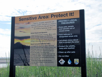
The Kenai dunes are a fragile ecosystem, easily destroyed by foot traffic and vehicle traffic. The grasses and sedges that grow along the beach area are vital to the beach ecosystem, because they provide shelter for wildlife, and their root systems stabilize the dunes so the sand does not blow away. Seemingly minor damage done by a single ATV crossing these areas is multiplied many thousands of times by repeated incursions by thousands of dipnetters during the season.
So before you dash off across the grassy knoll looking for a place to answer nature's call, be mindful of two things: first, you are not allowed to travel in many of these areas. That's why they are fenced off! Second, use the portable toilets. There will be thousands of dipnetters on the beaches with you, and if they all used the dunes for a public toilet, imagine the consequences. Use the facilities or bring your own. ATV use, where allowed, is restricted to the beach area itself. Respect the land.
Finally, many areas along the lower Kenai River that were once open to dipnetting have now closed. This is due primarily to habitat destruction as thousands of booted feet trample sedges and other vital habitat plants that provide food resources for salmon and trout fry along the margins of the lower river during high tides. These are vitally-important areas we need in order to preserve and protect the river and its resources. Stay on established walkways!
Local Impact
Nonlocal dipnetters have a huge impact on local residents in Kenai and the surrounding area. We jam up the boat ramps, we make a lot of noise, we fill up the local restaurants, and generally make a nuisance of ourselves for two or three weeks during the peak of the dipnetting season. Be mindful of the potential negative impact by driving responsibly, avoid excessive noise after 10pm, obeying local laws, respecting private land and picking up after yourself and others. Dipnetting is a privilege and our exercise of that privilege should not cost other people needlessly.
Safety Aspects
The Kenai River is very cold, and carries a load of glacial silt. The areas up near the Warren Ames bridge are bordered on both banks with thick mud, making it very easy to slip and end up in the river, or to become trapped in the mud at low tide. Avoid walking in areas where you can see watery mud, and never dipnet in these areas alone. Always wear a Personal Flotation Device whenever you are dipnetting, and if you are wearing chest waders, wear a wading belt over them. This will prevent the waders from completely filling up with water if you should fall in.
The lower river sees a lot of commercial boat activity during dipnetting season, and these boats can throw up a very large wake. If you have waded out to the point where the water is only a few inches from the top of your waders, you're going to get soaked when a boat comes by. Back off a bit! Sockeye salmon are frequently caught in the shallow water behind the line of dipnetters! You will feel fish bumping your net pole and your legs if you're out too deep anyway. Pay attention to any boat traffic moving up or down the river, and back up before the wake hits you.
The lower river also gets a lot of wind on some days, and you may see a shore break of wind-driven waves. Avoid the temptation to wade out to your wader tops, or the next big wave will fill your waders.
King salmon are sometimes caught by dipnetters, and when you get a king in your net, it is so strong that it can literally pull the net out of your hands, or pull you off balance. Be on the alert!
Health Concerns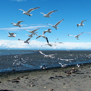
Seasonal elevated levels of fecal coliform and enterococci bacteria are found in the lower Kenai River, especially during dipnetting season. The bacterial overload is thought to be a result of large amounts of shorebirds (mostly gulls) that congregate in the lower river to consume fish waste discarded by dipnetters. Humans are exposed to the bacteria through ingesting contaminated river water. While most folks know better than to drink directly from the Kenai, they will often clean their fish in river water, rinsing raw fillets in the river, thereby contaminating the flesh. These bacteria can cause stomach ache, diarrhea and other symptoms.
Dealing with potential bacterial contamination is a war that can be fought on two fronts. First, discard fish waste by chopping it up into small pieces and tossing it into the main channel, where it can be carried out to sea. Second, avoid rinsing your fillets directly in the river. Instead, rinse them off at home with clean water.
A final precaution should be taken as well, and that is to pick up all your trash, including food scraps. Never deposit human waste in the beach areas; use the Porta-Potties that are stationed strategically in the river mouth area.
Locations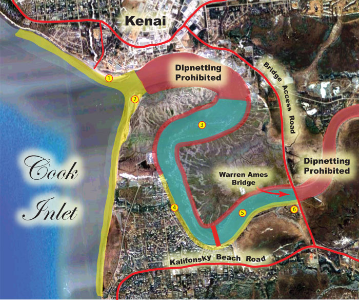
There are five primary locations to dipnet the lower Kenai River. There are other places too, but these are the main locations where you can catch fish. Note that on the map to the right, the area marked in yellow is open to shore-based dipnetting only, the red areas are off-limits for any dipnetting activity, and the green area is open to both shore-based and boat-based dipnetting. The open area ends at the Warren Ames bridge, above which dipnetting is not allowed.
1. North Beach. (yellow area on the map) The north beach access is via Spruce Drive, off of the Kenai Spur Highway in Kenai. You have to pay at the booth just before you come to the parking lot and beach access. If you intend to fish the east end of the beach, upriver, the easiest way is to take the access road to the left. There are a couple of beach access points from that road, and there is a public rest room at the end, with another access point. Park your rig and offload your gear, then return to the parking lot (there is no parking along this road). Alternatively, you can drive straight toward the beach from the toll booth, and you are allowed to park on the beach to the right. The sand on the beach is really soft in places, so you'll need to be in four-wheel-drive. If you expect high tides, park against the fence on your right as you enter the beach. There is no parking allowed to the left of the beach access road.
ATVs are not allowed on the north beach.
Depending on where you park, you may have to carry your gear a couple hundred yards or more. Some of the regulars use a beach cart for this purpose.
The north beach can become very chaotic during the peak of the run. Mark your gear well, so you can identify it easily, in case someone accidentally grabs the wrong dipnet pole as they are leaving. The most crowded end of the beach is the southeast end, with the crowds diminishing as your head north. The north end of the beach is relatively straight, and at low tide a large mud flat develops in front of the beach. By the time the mud flat drains, most dipnetters working that end of the beach take a break for a while, or move upriver to the east end. When the flats are flooded, however, the north end of the beach can develop a nasty shore break if the wind is up, as it frequently is. Use a longer dipnet pole to reach out beyond breaking waves. A shorter pole means you will probably get wet. Fish will travel in breaking waves, and just beyond. This is the zone you want to fish.
On the southeast end, the beach curves away to the left, and is more protected from wind-driven waves, which run more parallel to the beach in this area. The most popular method for fishing the north beach is the post method. Stand in the river and hold your net perpendicular to the shoreline. As the tide moves out, the current will pick up and holding bottom with your net will become difficult or impossible. Also, at low tide, the bottom becomes muddy and walking is more difficult. At the lower half of the outgoing tide, a conga line often develops at the far eastern end of the beach. If you're fishing a post method, and you find yourself in the way of the conga, pull your net and join in! It makes it much easier for everyone. A conga in this area can be made much easier if you secure a float to the top of your net. This allows the current to carry it along at about the same rate as your neighbors are traveling.
Restrooms
![]() Restrooms are located in two places on the North Beach. The first is a bank of portable restrooms (Porta-Potties) near the dumpsters at the end of Spruce Road, near the toll booth. The second set of restrooms are a bank of Porta-Potties located at the end of the beach access road that extends west from the toll booth. There are also permanent public toilet facilities there. Keep in mind that during busy weekends, there will be lines at these facilities. The City of Kenai does a great job keeping up with these facilities, and you can do your part by not depositing trash in the toilets.
Restrooms are located in two places on the North Beach. The first is a bank of portable restrooms (Porta-Potties) near the dumpsters at the end of Spruce Road, near the toll booth. The second set of restrooms are a bank of Porta-Potties located at the end of the beach access road that extends west from the toll booth. There are also permanent public toilet facilities there. Keep in mind that during busy weekends, there will be lines at these facilities. The City of Kenai does a great job keeping up with these facilities, and you can do your part by not depositing trash in the toilets.
North Beach Webcam (live)
http://www.ci.kenai.ak.us/node/723#sthash.R4CFTlMB
2. South Beach. (yellow area on the map) The south beach has similar characteristics to the north side. The west-facing part, the long beach that faces the Inlet, develops a tidal mud flat at low tide, with the main river channel apparent to the right. Dipnetters will fish the edge of this channel way out into the flat, but the risk in doing so is that you find yourself a long way from the beach with a fast incoming tide. Be very careful to avoid going too far out there, or you could be caught by high water. This area also gets pounded by waves if the wind is up. A more protected area is at the far north end of the beach, where it makes the curve upriver. Here the waves run parallel to the beach and are not as difficult to deal with.
The south beach offers some post-type fishing along the west end, but as you round the corner into the main channel itself, the current is too swift to hold bottom, and a large conga line is often in effect there. Go with the flow and you'll catch a lot more fish. Just watch what everyone else is doing, and join in the fun!
Restrooms
![]() Restrooms are located on the high ground along the curve of the beach. On busy weekends, there will be lines at these facilities. These facilities are maintained by the City of Kenai, and your efforts in keeping them clean and functional will allow them to service the toilets regularly. Do your part by not disposing of trash in the toilets!
Restrooms are located on the high ground along the curve of the beach. On busy weekends, there will be lines at these facilities. These facilities are maintained by the City of Kenai, and your efforts in keeping them clean and functional will allow them to service the toilets regularly. Do your part by not disposing of trash in the toilets!
3. Boat-Based Dipnetting Area. This section of the river is open to boat-based dipnetting, and carries an outboard restriction of 2-stroke or 4-stroke DFI outboards, with horsepower limitation. The prime time for dipnetting is usually two hours before high tide to two hours after high tide. But salmon will sometimes pull a surprise and show up en-masse at low tide. You never know. The risk of fishing out of a boat at low tide is running aground on a mud shoal, and there are several in the lower river. In our next map you can see one of the larger shoals exposed at low tide just below the Warren Ames bridge. Even if you run this area at high tide, the most productive dipnetting is going to be in the channels running along both sides of the shallow water.
4. East Bank, Lower Kenai River. The entire east bank of the Kenai River, from the Warren Ames Bridge to the begining of the North Beach Dipnetting area (#1 above) is closed to shore-based dipnetting.
5. Boat-Based Dipnetting Area. This section of the river is open to boat-based dipnetting, and carries an outboard restriction of 2-stroke or 4-stroke DFI outboards, with a 50 HP limitation. No outboards above 50 HP are allowed in this section. This restriction was put into place in order to protect the river from bank erosion. This restricted area starts at River Mile four and continues to the downstream edge of the Warren Ames bridge.
6. Warren Ames Bridge, South Side. There's a dirt road that pulls off the highway here, with plenty of parking, and restrooms. Dipnetting takes place under the bridge, and downriver a few hundred yards to a couple of tidal guts that drain off into the river. Like the north side, this area also is lined with muddy banks. But the riverbed here slopes off in a series of benches closer to the bridge. If you're not careful as you follow the falling tide, you may not realize that the end of these benches drops off a foot or two before leveling off. You can slip and end up going swimming. Some of the flat spots are very treacherous with watery mud that will mire you down for a long time before you can get free. Use extreme caution.
Closure Alerts! Beginning with the 2017 season, significant dipnetting location closures were made by the Alaska Department of Fish and Game. ALWAYS review the regulations before heading afield!
Restrooms
![]() Permanent public restrooms are located along the west side of the parking lot, toward the highway. On busy weekends, there will be lines at these facilities. These facilities are maintained by the City of Kenai, and your efforts in keeping them clean and functional will allow them to service the toilets regularly. Do your part by not disposing of trash in the toilets!
Permanent public restrooms are located along the west side of the parking lot, toward the highway. On busy weekends, there will be lines at these facilities. These facilities are maintained by the City of Kenai, and your efforts in keeping them clean and functional will allow them to service the toilets regularly. Do your part by not disposing of trash in the toilets!
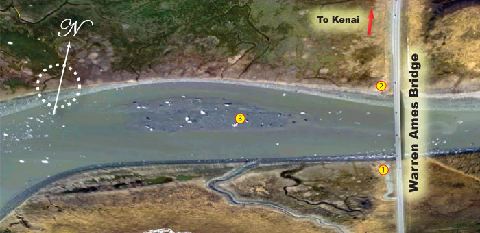
The above map shows the Warren Ames Bridge area in closer detail, with the south side (1) and north side (3) plainly visible. Boaters should note that a shallow mud shoal below the bridge (3) becomes exposed at low tide. The channels on either side of the shallows offer the best dipnetting, and the best upstream or downstream travel. If you run aground here, you could be stuck until the tide rises.
Where are the Fish?
When dipnetters aren't catching or cleaning fish, they're sitting on the tailgate of their pickup wondering where the fish are. Any time you get a group of dipnetters together, you will hear several theories of how to predict the arrival of the proverbial and greatly anticipated "Wall of Fish" all dipnetters dream of. Here are a few theories:
- You won't catch anything when the commercial boats are out. Experience has shown that this is simply not true. Commercial fishing boats off the Kenai River are restricted to fishing very specific zones, and the fishery is specifically managed to meet in-river escapement.
- Large numbers of fish will hit the Kenai three days after a large spike in the OTF. This has shown time and again to be inaccurate. Sometimes it works out that way, and other times it does not. You cannot plan your dipnetting trip based upon OTF numbers exclusively.
- Strong south winds will blow reds ashore at the mouth of the Kenai. Say what?
The single best indicator of fish in the river is the sonar count numbers, which are recorded and posted by the Alaska Department of Fish and Game, sometimes on a daily basis, and sometimes several times a day. The Alaska Outdoors Supersite receives a live feed of this data and we've posted it here on the site. Simply click on the icon below, select the river and year, and you'll know the status of the run.

Experienced dipnetters know that even with all the preparation involved in putting a dipnetting trip together, you can't catch fish that aren't there. Dipnetting the Kenai is all about timing. But the salmon in Upper Cook Inlet (UCI) are a shared resource, with commercial, sport, subsistence, personal use and the ecosystem itself all struggling for an allocation. The Alaska Board of Fisheries is tasked with ensuring that all groups are fairly represented.
What is the OTF?
In 1979, a project was launched for the purpose of estimating the total sockeye salmon return, including the timing of the run, in order to prevent over harvest, and to assist in estimating efficient commercial fishing operations. This project, the Offshore Test Fishery (OTF) consisted of chartering a commercial fishing vessel to conduct sample fishing at six established locations across the Inlet, located on a straight line from Anchor Point to the Red River Delta (Group A in the image below). The locations were selected with the belief that these locations would offer the best assessment of the numbers and timing of the sockeye salmon moving up the Inlet. In 2012, a similar project was launched north of the original OTF, with seven stations located on a straight line across the inlet from the general vicinity of the Kenai River mouth to the northern tip of Kalgin Island and on into Redoubt Bay (Group B in the image below). The purpose of the second OTF was to estimate the distribution of sockeye and silver salmon passing through to northern Cook Inlet. Both the southern and the northern OTF are conducted every year, and the findings are used to coordinate the timing and duration of commercial and subsistence openings, primarily for sockeye salmon.

What have we learned from the OTF?
Data collected by the Offshore Test Fishery in Cook Inlet has been used to support or debunk all sorts of theories about the movement patterns, run timings and destination of schools of sockeye in the Inlet. Perhaps one of the most surprising revelations was that "streams" of salmon move back and forth across the Inlet, seemingly at random. Fish caught on the east side of the Inlet are not necessarily bound for the Kenai River, and fish caught on the west side are not necessarily bound for rivers on the west side of the Inlet. So using spikes in the OTF numbers to predict when fish will hit the Kenai or Kasilof rivers can be very misleading.
NOTE: In the map shown above, two test fisheries are shown. The one indicated at "A" has been in place for many years. The one shown at "B" was funded in order to establish the destination of fish moving up into upper Cook Inlet. It was determined that Site B provided no definitive indication of what rivers the salmon were headed for, and this location was discontinued in 2014.
City of Kenai Dipnet App
The city of Kenai has developed an application that shows all the webcams, fees, and other information related to dipnetting on the Kenai River. Available for Apple and Android, this app is a must-have for anyone with a smartphone who dipnets the Kenai. Check it out HERE!
Celebrate Diversity! Pick up Someone's Trash!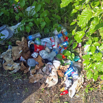
Very few Alaskans were born here, and most of those came from parents or grandparents who moved here from somewhere else. At the same time, we live among people who can trace their ancestry back to a time when Alaska was a very primitive place, devoid of the modern trappings of development. So Alaska is an amazing melting pot of diverse cultures, with vastly diverse perspectives on nature, the environment, and on how we conduct ourselves in the field. Most of the cultures represented in Alaska today have their roots in a strong love for the outdoors, and an intensely personal environmental ethic. Traditional Samoan culture has a very high regard for the environment and man's place in it. Filipino culture embraces a concept they call "pakikisama", or "harmony", in which getting along with others is respected. They also incorporate the principle of "hiya", or "shame". It's a sense of social decency that drives them to comply with public norms of behavior. Japanese culture embraces the notion of living with nature, as opposed to the Western concept of taming nature. Alaska native culture embraces a love for the land and the creatures that live on it, recognizing man's role as a participant in nature. Western culture, though having gone through times when care for the environment took a back seat to industrial progress, has come full-circle to now setting high standards of environmental protection and accountability. Gone are the days when tossing beer cans into the weeds at the old fishing hole, or flipping cigarette butts into the river were accepted practices. Now, we pick up after ourselves and those around us.
As interest in Alaska grows, we are seeing an increase in the numbers of people on our rivers and lakes. Some of these people come from places where strong environmental ethics were not in place, and they are bringing that here. We are seeing an increase in trash left behind by people who should know better. A bag full of trash, left lying where a trash can used to be, will attract other people to leave their trash in that place as well. Let's break that cycle, by hauling out our own trash.
Regardless of your cultural or social background, we are all Alaskans, and we share a strong environmental perspective. We don't want our home to become like some of the places we came from. The Alaskan environmental ethic drives us to not only haul out our own trash, but to bring along a couple of extra bags to pick up after other people as well. We teach our children to do the same, because this is our cultural norm. Many of the dipnetting sites in Alaska have no trash facilities, and garbage left behind by some becomes a burden others must clean up. Let's take the initiative to show our love for this amazing place by cleaning up after ourselves, and by leaving no trace of our campsites.
Resources
If you plan to fish anywhere on the Kenai Peninsula, you need a copy of Dave Atcheson's "Fishing the Kenai Peninsula" in your rig. If you're new to the area, a copy of The Milepost will help you plan your trip, providing maps and detailed information on the locations of campgrounds, cabins, places to eat, fuel stops and much more. While you're in the bookstore, you might also check out our maps of Kachemak Bay State Park, Kenai River (includes only the middle and lower sections of the river, from Skilak Lake to the mouth), and the Northwestern Kenai Peninsula map, which includes only the areas around Kenai, Soldotna, Sterling, Kasilof, and Nikiski. These are road maps, but they also show campgrounds, fishing areas and available species. Finally, check out Scott Haugen's excellent book, "Bank Fishing for Steelhead and Salmon" for excellent tips that will work on the Kenai River, Deep Creek and other places on the Kenai Peninsula.
Need More Information About Alaska Dipnetting?
We've got you covered! Check out the Dipnetting Menu on the left side of this page, or click one of the links below for more information.
Alaska Salmon Run Charts | Dipnetting Intro | Dipnetting Gear | Dipnetting Techniques | Caring for Your Catch
Dipnetting Locations
Check out the following links to the various dipnetting locations in Alaska.
Copper River | Kasilof River | Kenai River | Fish Creek | Susitna River | Twentymile River