Alaska Places
Region 1 North: Yakutat / Cordova Area
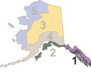
Region 1 (north) consists of the area surrounding Yakutat and Cordova. It's home to moose, brown bear, deer, and some excellent fishing opportunities.
Region 1 South: Southeast Alaska Panhandle
Southeast Alaska, commonly referred to as "The Panhandle", comprises a number of large islands and a strip of coastline that borders British Columbia to the east. The area is roughly 480 miles long and 100 miles wide, depending on where the measurement is taken. This region is the timber capitol of the state, and receives the highest annual rainfall in the entire state. Ketchikan is typical of the area, receiving an average of over thirteen feet of rain per year.
Region 2 East: North Gulf Coast, Prince William Sound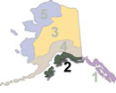
Region 2 East includes the coastal waters associated with Prince William Sound from the Cordova area north and west, extending west to include the entire Kenai Peninsula. This page is focused on the North Gulf Coast and the waters of Prince William Sound.
Region 2 West: The Kenai Peninsula
The Kenai Peninsula hosts some of the best road-accessible freshwater fishing in the state (the Kenai and Russian rivers, for example), and provides popular jump-off points for saltwater halibut, lingcod, rockfish and salmon fishing out of Valdez, Whittier, Seward, the Deep Creek / Ninilchik area, and Homer.
Region 2 West: The Kodiak / Afognak Archipelago
Region 2 includes the storied Kodiak and Afognak island archipelago, famous for brown bears, Sitka black-tailed deer, elk, and some of the best saltwater fishing in the state. Situated about 130 miles from the Kenai Peninsula, the islands are an oasis for shorebirds, marine mammals, dozens of varieties of freshwater and saltwater fishes, and animals that live on its slopes. One could spend decades here and not see it all.
Region 3 East: Eastern Arctic, Eastern Interior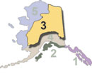
The dividing line between Region 3 (east) and the western portion of Region 3 is the Dalton Highway (the "Haul Road") from Prudhoe Bay south to Fairbanks, and south along the George Parks Highway. This area includes the bulk of the Alaska oil pipeline, including the oilfields at Prudhoe Bay.
Region 3 West: Central Interior
Region 3 (west) includes the interior of the state, west of the Dalton Highway, south through Fairbanks and west of the George Parks Highway. It contains the central Yukon and Kuskokwim rivers, the two longest rivers in the state. The land is mostly carpeted by black spruce forests, with frequent large openings of muskeg and tundra. Salmon fishing is mostly limited to the Yukon River watershed, however most of the region is far from the ocean, so it does not see the larger runs found in other regions. Fishing for grayling and northern pike is excellent. Big game species commonly encountered in Region 3 (west) include Dall sheep, moose, caribou, black bear and brown / grizzly bear.
Region 4 East: Interior, Anchorage and the Susitna Valley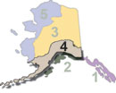
Region 4 (east) begins at the Canadian border north of Valdez and continues westward through the Anchorage area, along Cook Inlet to the western border of GMU 16, along the Western Alaska Range. The area offers excellent opportunities for climbers in Denali National Park, the Chugach Mountains, and the Wrangell- St. Elias areas. Fishing and hunting opportunities are seemingly endless, as are hiking, mountain biking, camping (both on and off the road system). Winter sports such as ice fishing, cross-country skiing, downhill skiing and snowmachining are popular winter sports here, with numerous road-based and remote options. Region 4 (east) has three downhill ski areas, all accessible by road from Anchorage; Hilltop, Arctic Valley, and Alyeska.
Region 4 West: Bristol Bay, the Alaska Peninsula and the Aleutian Islands
Region 4 (west) begins in the Iliamna / Lake Clark area and extends west to the Bristol Bay area and down the Aleutian Range to the end of the Alaska Peninsula, including the Aleutian Islands. It ends at the westernmost point of Alaska, Peaked Island, off the western shores of Attu Island in the Aleutian islands. The area offers excellent hunting and fishing opportunities and includes one of the crown jewels of Alaska, the blue-ribbon trout streams of the Bristol Bay area.
Region 5 North: Western Arctic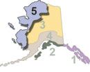
Region 5 (north) describes the northwestern coast of Alaska south to the border of GMU 18, and the western Arctic, over to the approximate center of the north coast area. It includes roughly half of the Brooks Range and the entire Seward Peninsula. Much of the land mass is covered in tundra, however there are some forests of spindly black spruce, willow, and alder in the southernmost areas. Though there are some larger villages in the area such as Nome, Kotzebue, and others, recreational access is generally limited to light commercial aircraft.
Region 5 South: Yukon-Kuskokwim Delta
Region 5 (south) includes most of the Yukon-Kuskokwim delta, together with portions of the Kuskokwim mountains. Much of the land mass is covered in tundra, however there are scattered forests of spindly black spruce, willow, and alder. The largest land holder in the area is the federal government, which controls the Yukon Delta National Wildlife Refuge, 19.16 million acres of wetlands habitat of great importance to waterfowl that nest here. The two largest towns in the region are Emmonak, a coastal village of around 760 people of mostly Alaska native descent, and Bethel, the largest community in western Alaska with around 6,300 residents. Aside from a limited road system in these towns, recreational access is generally limited to light commercial aircraft. Bethel is served by daily jet aircraft flights from Anchorage and is a regional hub for several air cargo carriers as well.
The Alaska outdoors: What is Alaska like?
Alaska is a vast land with diverse ecosystems, boundless expanses of forest, high arctic plains, thousands of miles of rivers, and entire mountain ranges within its borders. It is possible to spend a lifetime exploring the state and never see the same place twice. As you plan your Alaska outdoors trip, you need to know what to expect in the region you are visiting. What is the weather like? What are the terrain & vegetation like? What rivers flow through the area? What facilities are available? Can the area be accessed by road, or is flying necessary? Here you will find details on these, and more. We constantly update these pages, so if you don't find what you need, bookmark the page and check back.


