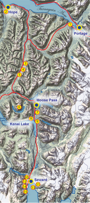
The Seward Highway from Ingram Creek to Seward
The Seward Highway extends south of Anchorage, along the shores of Cook Inlet's Turnagain Arm, until turning to the southwest onto the Kenai Peninsula. It's 52 miles from Anchorage to the Kenai Peninsula, which you can make on a typical summer day in 40 minutes or so. There are numerous places to pull off, and many passing lanes along the way, so if you're driving a motorhome or pulling a larger boat, please utilize these pullouts and passing lanes so faster traffic can get around you if necessary. In Alaska, it is illegal to hold up five or more vehicles if a passing lane or turnout is available.
How Turnagain Arm got it's Name. In 1778, Captain James Cook sailed up the inlet that would later bear his name, in search of the storied Northwest Passage. Owing to shallow water near the head of the Inlet, at the site of what would later become Anchorage, Cook launched a boat manned by William Bligh (of HMS Bounty fame). Bligh and his crew moved up the north arm of the Inlet, confirming his earlier suspicion that the arm was only the inlet of a river (the Susitna, Matanuska, and Knik rivers all enter the Knik Arm). He turned the boat around and made his way up the southern arm, also confirming that the arm ended at a river mouth (the Twentymile and Portage rivers flow into the end of the arm). So he "turned again" and headed back to the ship, naming that arm "Turnagain".
 As you make your way south along the Seward Highway, look for Dall sheep in the vicinity of Beluga Point; they can be often seen feeding in the cliffs and outcrops above the highway. Cook Inlet is host to the second-highest tide changes in the world, behind Canada's Bay of Fundy. It's not uncommon to see changes in water depth of 30 feet or more. The tidal flow causes Turnagain Arm to resemble a river more than an inlet, with rapids and large waves appearing suddenly at times. As the tide changes, a bore tide often develops. If your timing is right, you may see the bore tide making it's way up the Inlet at speeds of 5-8 miles an hour. It's a popular destination for paddleboarders and surfers, and you can watch them from any of several turnouts along the Arm.
Here is a listing of the popular fisheries between Ingram Creek and the town of Seward:
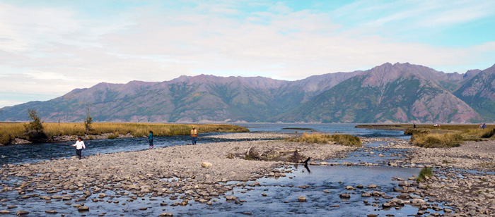
1. Ingram Creek. Species: Pink salmon, silver salmon, Dolly Varden. Access: Exit the highway at mile 75.3, park in the large parking lot, and walk a few yards to the creek. Avoid walking in the mud along the Inlet; people have become trapped in the mud and drowned on the incoming tide in this area! Concentrate your efforts upstream of the bridge.
Amenities: None
2. Resurrection Creek. Species: Pink salmon, silver salmon, Dolly Varden. Access: Take the Hope cutoff to the town of Hope. The creek is accessible from several locations in town and out toward the Inlet. Use extreme caution walking around below the tide line, as the mud can present an entrapment hazard. Hope has an RV park, and a state campground is located just west of town, at MP 17.8 of the Hope Highway. The Porcupine Campground was reconstructed in 2011 and offers several amenities, including very scenic views of Cook Inlet. Protective vegetation in the campground, including many larger trees, offers protection from winds that frequently surge down Turnagain Arm.
Amenities (Seaview RV Park): ![]()
![]()
![]()
![]()
![]()
Amenities (Porcupine Campground): ![]()
![]()
![]()
![]()
![]()
![]()
3. Lower Summit Lake. Species: Dolly Varden, rainbow trout (stocked). Access: MP 47.6.
Amenities: None
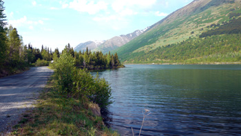
4. Upper Summit Lake. Species: Dolly Varden, rainbow trout (stocked). Access: Turn off the highway at MP 46, and drive the short dirt road to state-maintained Tenderfoot Campground. There's a cafe at the turnoff, with some cabin rentals available. Some shore fishing is available, however, there is brush right to the shoreline. A boat or raft is a better choice, and there is a boat launch at Tenderfoot. The campground has 35 sites, no RV hookups. This is a fee-based campground, with advance reservations recommended AT THIS LINK.
Amenities: ![]()
![]()
![]()
![]()
![]()
5. Summit Creek. Species: Dolly Varden, rainbow trout. Access: MP 42.6. Summit Creek is the outflow of Summit Lake.
Amenities: None
6. Crescent Lake. Species: Dolly Varden, grayling. Access: Park at MP 33.1, near the Carter Lake trailhead. Hike three miles to Crescent Lake inlet. The trail takes you past Carter Lake (which also offers good grayling fishing), before arriving at Crescent Lake. When you get to the lake, you can take the trail to the right for camping at designated campsites, but there is a better campsite section along the lake itself. Take the trail to the left to enter the primitive trail (mountain bikes not allowed after this point), which takes you around the outside curve of the lake and provides access to either of the two cabins. The trail becomes progressively more overgrown during the summer months, so be prepared for slower progress. Another way to access Crescent Lake is via the Crescent Creek Trail, which starts at the Sterling Highway side. Take the turnoff at Kenai Lake to the Quartz Creek Campground, but follow the dirt road past the campground and to the very end. That's where the trailhead is located. This trail is popular with mountain bikers, but once they get to the lake, they are not allowed on the primitive trail around the lake. There are two cabins available at Crescent Lake (see review below). Fishing can be done with a packraft, or by walking along the shore. Dolly fishing is marginal, however, Crescent Lake offers outstanding grayling fishing from July through September. The wind can come up suddenly on this lake, so wear a life jacket if you plan to float.
Amenities: ![]()
![]()
![]()
Crescent Lake Cabin: Cabin is located at the far west end of the lake, near the Crescent Creek Trail. 12'x14', sleeps four on provided bunks (bring your own bedding), and can accommodate four more sleepers on the floor. Includes table, benches, countertops and a rowboat with oars. Life jackets are not included, but because of high winds on the lake, life jackets are recommended. Bring your own. Advance reservations recommended AT THIS LINK.
Crescent Saddle Cabin: Cabin is located along the midpoint of the primitive trail, at the curve of the lake. 12'x14', sleeps six (bring your own bedding). Includes table, wood stove (bring your own wood, as local wood will have been depleted by other campers) and a rowboat with oars. Life jackets are not included, but because of high winds on the lake, life jackets are recommended. Bring your own. Advance reservations recommended AT THIS LINK.
7. Lower Trail Lake. Species: Dolly Varden, rainbow trout, lake trout. Access: MP 25.3 Lower Trail Lake is full of suspended glacial silt, and visibility is almost zero. Try fishing with roe at the outlet for the best results.
Amenities: Cabin rentals are available nearby in Moose Pass, and there is a local store where grocery items can be purchased.
8. Trail River. Species: Dolly Varden, rainbow trout. Trail River is the outflow of Lower Trail Lake and is glacial. Therefore the water is nearly opaque with suspended glacial silt. Fishing conditions are marginal at best. Access: The highway crosses Trail River at MP 25.3.
Amenities: None
9. Ptarmigan Creek. Species: Dolly Varden, rainbow trout. Ptarmigan Creek hosts a run of sockeye salmon, and rainbows and Dollies follow the salmon in hopes of picking off eggs. Fish egg patterns or flesh flies for the best results during the sockeye run. Access: Turn off the highway at MP 23.4 and follow the gravel road parallel to the highway to a parking area near the creek.
Amenities: None.
10. Resurrection River. Species: Pink salmon, chum salmon, silver salmon, Dolly Varden. Access: The highway crosses the river at MP 2.8.
Amenities: ![]()
![]()
![]()
![]()
![]()
![]()
![]()
11. Spring Creek. Species: Pink salmon, chum salmon, silver salmon, Dolly Varden. This is a saltwater fishery targeting returning hatchery fish. The most common method of fishing here is snagging, using weighted treble hooks. Fish can also be caught using a variety of spoons and spinners. Most anglers fish the mouth of the creek, or wade offshore. Access: Drive to the end of Nash Road in Seward. There's a campground there, but amenities are few.
Amenities: ![]()
12. Seward Lagoon Creek. Species: King salmon, pink salmon, chum salmon, silver salmon, Dolly Varden. This is a saltwater fishery targeting returning hatchery fish. The most common method of fishing here is snagging, using weighted treble hooks. Fish can also be caught using a variety of spoons and spinners. Access: Located below the waterfall, via the dirt road out of Seward as you head to the right around the bay to Lowell Point.
Amenities: None
13. Resurrection Bay. Species: King salmon, pink salmon, chum salmon, silver salmon, Dolly Varden. This is a saltwater fishery targeting returning hatchery fish. The most common method of fishing here is snagging, using weighted treble hooks. Fish can also be caught using a variety of spoons and spinners. Access: Shoreline areas in the town of Seward, as well as along both shorelines at the head of Resurrection Bay.
Amenities: None.
14. Lowell Point. Species: King salmon, pink salmon, chum salmon, silver salmon, Dolly Varden. This is a saltwater fishery targeting returning hatchery fish. The most common method of fishing here is snagging, using weighted treble hooks. Fish can also be caught using a variety of spoons and spinners. Fish any of the shoreline areas. Relatively shallow water in this area allows wading some distance from the shore if you find that the fish are farther from shore. Access: Drive around the right-hand side of the bay to MP 0.3, where you will find Miller's Landing private campground. Farther along the road you come to the Lowell Point State Recreation Site. The site offers few amenities, but it is the trailhead for the Caine's Head Trail.
Amenities (Miller's Landing private campground): ![]()
![]()
![]()
![]()
![]()
![]()
![]()
![]()
![]()
Amenities (Lowell Point State Recreation Site): ![]()
![]()
![]()
15. Tonsina Creek. Species: King salmon, pink salmon, chum salmon, silver salmon, Dolly Varden. This is a saltwater fishery targeting returning hatchery fish. The most common method of fishing here is snagging, using weighted treble hooks. Fish can also be caught using a variety of spoons and spinners. Fish the alluvial fan where the river flows into the bay, or wade out and cast to schooling fish offshore. Access: Hike 2.5 miles via the Caine's Head Trail from the Lowell Point State Recreation Area, or via boat drop-off. The facility at Miller's Landing rents boats that can be used for this purpose.
Amenities: ![]()
NOTE: There are a number of places to camp in the Seward area. If one campground is full, try another! Most campgrounds accept advance reservations, and this is the best way to go. For the best selection, make your reservations during the winter prior to your visit. Regardless of which campground you stay in, your vehicle is the key to experiencing all the freshwater and saltwater fishing opportunities in the Seward area. Popular campgrounds are:
- Miller's Landing (private campground around the west side of the bay near Lowell Point)
- Seward Waterfront Campground (right on the waterfront in town; includes six separate campgrounds, some of which are tent-camping only, others allow RV camping)
- Spring Creek Campground (end of Nash Road on the east side of the bay)
- Stoney Creek RV Park (private campground located six miles north of town)
Resources
If you plan to fish anywhere on the Kenai Peninsula, you need a copy of Dave Atcheson's "Fishing the Kenai Peninsula" in your rig. If you're new to the area, a copy of The Milepost will help you plan your trip, providing maps and detailed information on the locations of campgrounds, cabins, places to eat, fuel stops and much more. While you're in the bookstore, you might also check out our maps of Kachemak Bay State Park, Kenai River (includes only the middle and lower sections of the river, from Skilak Lake to the mouth), and the Northwestern Kenai Peninsula map, which includes only the areas around Kenai, Soldotna, Sterling, Kasilof, and Nikiski. These are road maps, but they also show campgrounds, fishing areas and available species. Finally, check out Scott Haugen's excellent book, "Bank Fishing for Steelhead and Salmon" for excellent tips that will work on the Kenai River, Deep Creek and other places on the Kenai Peninsula.
Species
Check out these species pages for the types of fish you may encounter on the Kenai Peninsula:
King Salmon | Pink Salmon | Red Salmon | Silver Salmon | Chum Salmon | Halibut | Hooligan | Lingcod | Pacific Cod | Rockfish | Salmon Shark | Grayling | Lake Trout | Pike | Rainbow Trout | Dolly Varden
Click on the following links to review angling opportunities in the various areas of the Kenai Peninsula.
Kenai Peninsula Fishing Intro | Upper Kenai Peninsula Fishing | Central Kenai Peninsula Fishing | Lower Kenai Peninsula Fishing | Kenai Peninsula Marine Fishery | Kenai Peninsula Clamming | Seward Saltwater Fishing | Seldovia Fishing