The Sterling Highway from Tern Lake to Soldotna
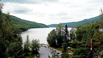
The Sterling Highway extends west from its intersection with the Seward Highway at Tern Lake, to its eventual termination at the Homer Spit, in Homer. In this section, we will look at the section from Tern Lake to the town of Soldotna, on the Kenai River. We will include all sections of the Kenai River in this area as well. The upper section of this area starts in the Kenai Mountains, and as you pass the Skilak Loop Road turnoff and Jean Lake, you exit the mountains and find yourself on the Kenai Lowlands, which extend all the way to Homer.
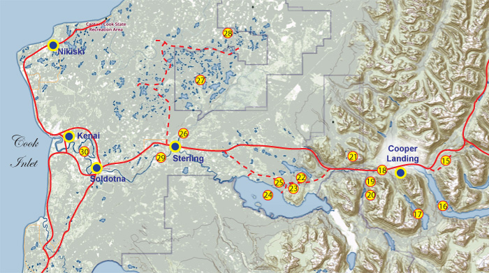
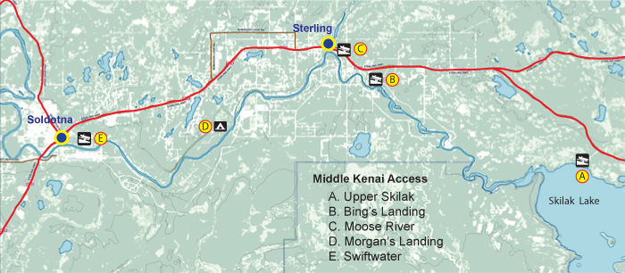
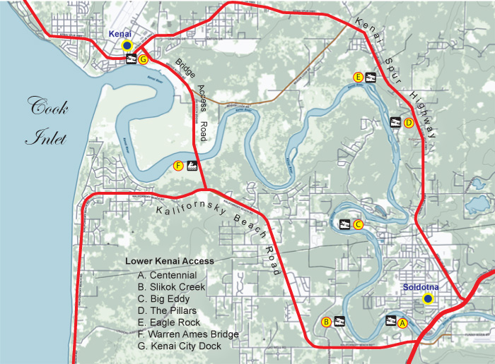
Consult the following map for specific locations on the Central Kenai Peninsula.
16. Quartz Creek. Species: Dolly Varden, rainbow trout, grayling, whitefish. This is a popular roadside fishery flowing from Tern Lake to Kenai Lake, with numerous pull-offs from the highway, allowing access. Quartz Creek is home to healthy populations of brown bears and black bears, which are drawn to the creek by the abundant runs of red and silver salmon (the creek is closed to salmon fishing). Use extra caution when fishing Quartz Creek, due to thick, high grass and other vegetation combined with bears on the river. Access: Pull off the highway at the lower end of Tern Lake and fish the outflow, or continue west on the Sterling Highway and fish the creek by parking at any of several turnouts and hiking the short distance to the river. Quartz Creek can also be fished at the lower end of the Quartz Creek Campground. The campground offers many amenities, as listed below. Reserve a campsite AT THIS LINK.
Amenities: ![]()
![]()
![]()
![]()
![]()
![]()
![]()
17. Kenai Lake. Species: Dolly Varden, lake trout, rainbow trout. Kenai Lake is a spawning site for sockeye salmon, however, the lake is glacial in origin and holds a heavy load of suspended, aquamarine silt. This makes it difficult for fish to see your offering unless you focus your efforts on clearwater tributaries into the lake. Boaters will have the best opportunities by concentrating on these tributaries, or by fishing the outlet of the lake. Access: Several access points, most notably from the Quartz Creek Campground, and the boat launch where the Kenai River flows out of the lake. There is a lot of private property along the lakeshore, so use caution to avoid trespass issues.
Amenities (Quartz Creek Campground): ![]()
![]()
![]()
![]()
![]()
![]()
![]()
Amenities (Kenai River Bridge): ![]()
![]()
18. Cooper Lake. Species: Dolly Varden, rainbow trout. Cooper Lake was the result of a hydroelectric project which dammed Cooper Creek in the 1960s. A restoration effort is in place to restore salmon rearing habitat in Cooper Creek via seasonal outflows from the dam at Cooper Lake. Fishermen should expect seasonal fluctuations in the water depth in Cooper Lake as a result of this project. Access: Turn left at MP 8.7, continue on Snug Harbor Road past the Y to the parking area. It's about 12 miles from the bridge at Kenai Lake to Cooper Lake. There's a boat ramp at Cooper Lake, for hunters or fishermen interested in accessing the area.
Amenities: ![]()
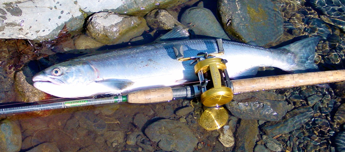
19. Kenai River, Upper. Species: Sockeye salmon, silver salmon, pink salmon, Dolly Varden, rainbow trout, whitefish. The Upper Kenai is a popular drift-only fishery (no powerboats between Kenai Lake and Skilak Lake). Most of the river is fly-fishing only, however the most common way to fling a fly on the Upper Kenai is with a spinning rod or a drift rod with 20-lb. line, owing to the strong current and the acrobatic nature of it's most popular fish, the sockeye salmon. One of the most popular fisheries in South-central Alaska, the Upper Kenai sees thousands of anglers each summer. The river is home to resident rainbow trout and Dolly Varden that grow to unusual size in the rich environment. The river also sees two runs of sockeye salmon, a run of kings (this area is a spawning ground for king salmon, and fishing for them is closed), and one run each of pink salmon and silvers, that find themselves in the Upper Kenai about the same time as the second run of sockeye. The area is home to both brown bears and black bears, so anglers need to be very careful and follow "bear safe" tactics on this river. Bring a pack to carry your fish and gear, and wear it on your body at all times while fishing. Bears have become acclimated to people in this area and will grab packs left unattended. Access: Floaters can start their drift at the boat ramp at the outlet of Kenai Lake. The upper mile or two are relatively calm flat water, where rowing is necessary. Fishing in this section is marginal, so if you want to skip that section you can put in at the Russian River ferry crossing, at river mile 8.2, measured from the bridge at Kenai Lake. You will miss some good areas, but this puts you in the thick of the action. The only other access for rafters on the Upper Kenai is at the take-out at Jim's landing, at river mile 12.7. If you miss Jim's Landing, you'll end up floating the canyon section down to Skilak Lake, which puts 5.7 more miles on the run. The canyon is rated at Class III at some flow levels and should not be attempted by novice boaters. Some anglers opt to float the canyon and camp overnight at Skilak, where outboards are legal. Skilak Lake is known for wind and dangerous whitecaps that can come up suddenly, creating serious hazards for boaters. Your best bet for calm weather is usually the early morning hours or the evening if the weather is good. The run is about 6.25 miles. You can opt to row it, but it's going to take a couple of hours if the weather is calm. Never attempt the crossing without life jackets!
Bank fishing is possible along many areas on the Upper Kenai, with the most popular being in the area of the Russian River Ferry crossing. If you take the ferry across, be advised that it closes every night at 11 pm. Many anglers have ended up overnighting on the other side of the river because they missed the ferry! Bank fishing is possible elsewhere along the Upper Kenai as well, and there are several turnouts here and there, with trails to the river. Use extreme caution in this area, as there are numerous brown bears and black bears fishing along the river during the summer and fall. These bears are acclimated to humans, and often show no fear, and some see you as a source of food. Keep your fish and your food in your backpack, and wear your pack! Never leave a pack on the shore, and avoid leaving fish on a stringer in the water. Bears are accustomed to this and will run you out of the area or worse.
There are numerous amenities along the river, including nearby groceries, cafes, fuel, a store with fishing tackle, and even rods and waders to rent. Ice is available, and some outfits will freeze your catch for shipment home.
Amenities: ![]()
![]()
![]()
![]()
![]()
![]()
20. Russian River. Species: Sockeye salmon, silver salmon, Dolly Varden, rainbow trout. The clear waters of the Russian River are a draw to thousands of anglers every summer, mostly in pursuit of sockeye salmon. The stream can be waded in many places, however, the swift current and deep holes in many areas mean anglers must use extreme caution when crossing the Russian. This area is "bear central" so keep on your toes and always travel in groups if you're hiking the river trail in the late evening or early morning hours (the prime time for bears to be actively feeding on the river). Anglers have been mauled and severely injured here, so be extremely cautious. Access: There are two ways to get to the Russian River: 1) Park at the Russian River Ferry crossing, and take the ferry across the Kenai River to fish the Kenai and the lower reaches of the Russian River, or 2) take the Russian River Campground road at MP 52.7, continue to toll booth, and on to any of several parking/camping areas in the Russian River Campground. Though some drive-up camping is possible, most campers make reservations well in advance of the season. Advance reservations can be made AT THIS LINK. Day-use parking is on a first-come, first-served basis, as space is available. During peak times there will be a line of vehicles all the way out to the highway, so plan ahead!
Amenities: ![]()
![]()
![]()
![]()
![]()
![]()
21. Lower Russian Lake. Species: Dolly Varden, rainbow trout. Access: There are three ways to get to Lower Russian Lake: 1) floatplane, 2) hike along the trail from the Russian River Campground (about three miles), or 3) take the hiking trail from the Russian River trailhead, just past the toll booth at the entrance to the campground. This trail is much better than the river trail and the gradient is mostly flat, with some short inclines. It's a three-mile hike to the river. Once you get to the river, you can hike the river trail downstream to the falls for a beautiful view of sockeye salmon stacked up below a fish ladder that's on the other side of the river. Fishing is prohibited in the falls area. If you go to the left at the river, you come to a weir that's operated by the Alaska Department of Fish and Game, for the purpose of counting the sockeye and silver salmon runs. Fishing is prohibited in this area as well, and you are not allowed to walk on or near the weir. The Barber Cabin is available by reservation AT THIS LINK, for those who prefer the comfort of a cabin. The cabin is 16'x20', and can sleep four comfortably on the provided bunk beds (bring your own bedding), and there's room for four more people sleeping on the floor. The cabin also has a wood stove (bring your own wood, as local wood will have been burned by other campers), a table, benches, countertops, an outhouse, and a rowboat with oars. There are plenty of places to set up a tent in the area, but the vegetation along the lakeshore is thick in places, so campsite selection is somewhat thin. Bears frequent the area, so use a bear-proof container for your food or hang it between trees. Some campers use an electric fence around their sleeping area as an added precaution.
Amenities: ![]()
![]()
![]()
22. Fuller Lakes. Species: Grayling in Lower Fuller Lake and Dolly Varden in Upper Fuller Lake. Lower Fuller Lake offers excellent grayling fishing at times, but anglers would do well to use a float tube or a packraft for accessing the fish, as some of the shoreline areas are obstructed by vegetation. Some established campsites are visible along the trail between the lakes, but it is recommended that anglers reduce their impact on this area as it sees heavy use at times. Campfires are not recommended, as the surrounding vegetation can be easily damaged. Use a backpacking stove for cooking. Water should be filtered, boiled, or treated before drinking. Access: Pull off to the north side of the highway to the trailhead at MP 57.2. The hike to Lower Fuller Lake is 1.2 miles, and the trail is fairly steep. A beaver dam marks the outflow of the lake. The upper lake is accessed by the trail that continues along the west side of Lower Fuller Lake.
Amenities: ![]()
23. Hidden Lake. Species: Kokanee, rainbow trout, lake trout, Dolly Varden. Shore-based fishing opportunities are very limited here; your best bet is to use a boat to access the better areas. The lake is 148 feet deep and has many steep drop-offs along points and off the various islands. You can view a bathymetric map of Hidden Lake AT THIS LINK for more details. Hidden Lake is a popular wintertime ice fishing location. Access: Turn off on the Skilak Loop Road at MP 58, travel 3.6 miles; Hidden Lake Campground is on the north side of the road. Note that Hidden Lake campsites are on a first-come, first-served basis (no reservations accepted).
Amenities: ![]()
![]()
![]()
![]()
![]()
![]()
![]()
![]()
24. Upper Ohmer Lake. Species: Dolly Varden, rainbow trout. The area is closed to hunting or trapping, with the exception of an archery season for small game, from October 1- March 1. A 16'x18' cabin is available at Upper Ohmer Lake. It sleeps four comfortably on the provided bunk beds (bedding is not provided; bring a sleeping bag and pad). There is room for a couple of additional people sleeping on the floor. The cabin includes a table and benches, a wood stove (bring your own wood, as other campers will have burned the available wood), a campfire ring, a rowboat and oars (bring your own lifejackets), and an outhouse. This cabin is available by reservation only, from the Kenai National Wildlife Refuge AT THIS LINK. Access: MP 7.7 Skilak Loop Road.
Amenities: ![]()
![]()
![]()
![]()
25. Skilak Lake. Species: Sockeye salmon, silver salmon, pink salmon, Dolly Varden, lake trout, rainbow trout. The lake is glacial in origin and carries a heavy load of suspended glacial flour, making it impossible for fish to see flies and lures. Anglers will achieve the best results by fishing the clearer inlet streams into the lake, and by using brighter-colored lures. Bait fishing is prohibited in Skilak Lake. Access: Skilak lake can be accessed by floating down the Upper Kenai River, through the canyon, and into the lake, and by highway vehicle via the Skilak Loop Road at either the upper end or the lower end. The Upper Skilak Lake Campground can accommodate RVs, and a dump station is located along the Skilak Loop Road, between the upper and lower campgrounds.
Amenities: ![]()
![]()
![]()
![]()
![]()
![]()
26. Lower Ohmer Lake. Species: Dolly Varden, rainbow trout. Access: Turn off at MP 8.6 on the Skilak Loop Road, take the short gravel road to Lower Ohmer Lake Campground. The campground is tiny; only three campsites are available. Potable water is not available at this campground; either filter, boil or treat lake water for drinking, or fill your water jug at the nearby Upper Skilak Lake campground.
Amenities: ![]()
![]()
![]()
![]()
27. Moose River. Species: King salmon, sockeye salmon, pink salmon, silver salmon, Dolly Varden, rainbow trout. Access: Drive the South Tongass Highway to the Beaver Falls hatchery and the Ketchikan Public Utilities (KPU) power station at the end of the highway. The trail to the lower lake follows the KPU service road two miles to the lower lake. Picnic tables and a pit toilet are located here. The road/trail continues a half-mile to the Lower Silvis Lake powerhouse. Cross the bridge at the powerhouse and continue along the western shore to the upper lake.
Amenities: ![]()
![]()
![]()
![]()
![]()
![]()
![]()
28. Swanson River Canoe Trail. Species: Silver salmon, sockeye salmon (in Moose River), Dolly Varden, rainbow trout. Access: Turn off from the Sterling Highway MP 83.4, onto the Swanson River Road. The road extends 17.2 miles to the Swan Lake Road junction, and provides access to the Swanson Lakes Canoe Trail system, along with the Swan Lakes Canoe Trail system. The Swanson River Canoe Trail system involves 40 lakes, with portage trails between them, and 46 miles of the Swanson River, for a total potential distance of 80 miles. Not all floaters cover the entire area of course, and numerous shorter trips can be taken in this area. There are no developed campsites or amenities in this area, but many of the lakes have obvious campsites that have been used for many years. Care should be taken to use these established campsites, rather than hacking another out of the Bush. Note that some of the roadside lakes have amenities such as toilets, campgrounds, and such.
Amenities: ![]()
![]()
![]()
29. Swan Lake Canoe Trail. Species: Silver salmon, sockeye salmon (in Swanson River), Dolly Varden, rainbow trout. Access: Turn off from the Sterling Highway MP 83.4, onto the Swanson River Road. The road extends 17.2 miles to the Swan Lake Road junction, and provides access to the Swanson Lakes Canoe Trail system, along with the Swan Lakes Canoe Trail system. The Swan Lake Canoe Trail system involves 30 lakes, with a network of portage trails between them, and 46 miles of the Moose River, for a total potential distance of 60 miles. It's not necessary to float the entire system, and numerous shorter trips can be taken in this area. There are no developed campsites or amenities in this area, but many of the lakes have obvious campsites that have been used for many years. Care should be taken to use these established campsites, rather than hacking another out of the Bush. Note that some of the roadside lakes have amenities such as toilets, campgrounds, and such.
Amenities: ![]()
![]()
![]()
30. Kenai River, Middle. Species: King salmon, sockeye salmon, silver salmon, pink salmon, Dolly Varden, rainbow trout, whitefish. Access: There are many public access points on the Middle Kenai River, from which shore-based fishing is possible. Expect such places to be crowded, however, especially during the peak of the sockeye salmon run. One way to beat the crowds is to either float the river or use a powerboat to access the better areas. Floaters and drift-boaters should be aware that there are a lot of powerboats on the middle river, so be cautious to avoid areas of heavy traffic. Be advised that there is a lot of private land along the Middle Kenai; respect private property. Starting at the upstream end, it's possible to float from the lower Skilak Lake campground to the river mouth, a distance of 1.4 miles. Similar to the Upper Kenai below Kenai Lake, the farthest upper reaches of the Middle Kenai are relatively flat and rapids-free. The next point of interest is Bing's Landing, located 11.12 river miles downstream from the confluence with Skilak Lake. Some floaters opt to take out at Bing's, to avoid having to run Class II Naptown Rapids. If you do want to experience the rapids, you could either float from the lake down or put in at Bing's and shoot the rapids just around the first bend. The next access point below Bing's Landing is at the confluence of Moose River, a scant 3.2 miles downstream. There's a campground at the Moose River confluence, along with a boat ramp. Below the Moose River confluence, the next major access point is Morgan's Landing, located five miles downstream of the Moose River confluence. Some shore-based fishing is possible here, but there is no boat ramp. If you're rafting, and you're up for a short portage, you could pack your boat up to the parking area at Morgan's Landing at this point. If you must have a boat ramp, the nearest downstream ramp is at the Swiftwater Campground. That's another 8.1 miles downstream, on the outskirts of Soldotna.
 A: Lower Skilak Lake Campground: The Lower Skilak Lake Campground offers 14 campsites, which include picnic tables and fire rings (bring your own wood, as most of the dead wood in the area will be burned by other campers). This campground is somewhat busier than the Upper Skilak Campground, because of heavier powerboat use (powerboats are illegal on the Upper Kenai, hence the reduced traffic in the upper campground). The campground can accommodate RVs, however, there are no water or sewer hookups. A dump station is located on the Skilak Lake Loop Road, between the upper and lower campgrounds. The campground also has a boat ramp, and parking for vehicles with trailers.
Amenities: ![]()
![]()
![]()
![]()
![]()
![]()
![]()
![]()
![]()
B: Bing's Landing: Bing's Landing is situated immediately above Class II Naptown Rapids, with it's exposed boulders and some whitewater. Bing's has a boat ramp, a large parking area, and a fee-based campground with several amenities.
Amenities: ![]()
![]()
![]()
![]()
![]()
![]()
![]()
C: Moose River: Moose River is located at MP 82.3, on the east side of the highway. It's the home of the Isaac Walton Campground, with a number of amenities of interest to fishermen, including a boat ramp, a fish cleaning station, potable water, and camping/parking facilities. This is a fee-based campground.
Amenities: ![]()
![]()
![]()
![]()
![]()
![]()
D: Morgan's Landing: Morgan's Landing doesn't have a boat ramp, so if you're rafting you will have to portage your gear uphill to the parking area. The campground is nice, with 51 campsites, a 35' RV size limit, and picnic tables at every campsite. There's a network of trails and ample access to the river for fishing. Access: Turn off at MP 84.9 onto Scout Lake Loop Road. Travel 1.6 miles to the intersection with Lou Morgan Road. Right 2.4 miles to a gravel road on the right. 1.5 mile to Morgan's Landing.
Amenities: ![]()
![]()
![]()
![]()
![]()
![]()
E: Swiftwater Campground: Owned and operated by the city of Soldotna, Swiftwater offers 40 campsites, a boat launch, plenty of shoreline fishing opportunities (elevated fish walks that are designed to preserve riparian habitat), and rest room facilities. There's even a covered pavilion, so you can eat your lunch under cover in case it rains. No advance reservations are available, and camping at Swiftwater is on a first-come, first-served basis only.
Amenities: ![]()
![]()
![]()
![]()
![]()
![]()
![]()
![]()
31. Kenai River, Lower. Species: King salmon, sockeye salmon, silver salmon, pink salmon, Dolly Varden, rainbow trout, whitefish. The Lower Kenai is arguably the most popular river-based powerboat fishery in the state of Alaska. On a typical weekend during the peak of the king salmon season, expect crowded boat launches, and lines of boats at all the best holes on the river. This is one of the most productive fisheries in the state of Alaska. Access: There are numerous access points to the Lower Kenai River, as listed below.
A: Centennial Campground: The Lower Skilak Lake Campground offers 14 campsites, which include picnic tables and fire rings (bring your own wood, as most of the dead wood in the area will be burned by other campers). This campground is somewhat busier than the Upper Skilak Campground, because of heavier powerboat use (powerboats are illegal on the Upper Kenai, hence the reduced traffic in the upper campground). The campground can accommodate RVs, however, there are no water or sewer hookups. A dump station is located on the Skilak Lake Loop Road, between the upper and lower campgrounds. The campground also has a boat ramp, and parking for vehicles with trailers.
Amenities: ![]()
![]()
![]()
![]()
![]()
![]()
![]()
![]()
![]()
B: Slikok Creek: Bing's Landing is situated immediately above Class II Naptown Rapids, with it's exposed boulders and some whitewater. Bing's has a boat ramp, a large parking area, and a fee-based campground with several amenities..
Amenities: ![]()
![]()
![]()
![]()
![]()
![]()
![]()
C. Big Eddy: Moose River is located at MP 82.3, on the east side of the highway. It's the home of the Isaac Walton Campground, with a number of amenities of interest to fishermen, including a boat ramp, a fish cleaning station, potable water, and camping/parking facilities. This is a fee-based campground.
Amenities: ![]()
![]()
![]()
![]()
![]()
![]()
D. The Pillars: Moose River is located at MP 82.3, on the east side of the highway. It's the home of the Isaac Walton Campground, with a number of amenities of interest to fishermen, including a boat ramp, a fish cleaning station, potable water, and camping/parking facilities. This is a fee-based campground.
Amenities: ![]()
![]()
![]()
![]()
![]()
![]()
E: Eagle Rock: Moose River is located at MP 82.3, on the east side of the highway. It's the home of the Isaac Walton Campground, with a number of amenities of interest to fishermen, including a boat ramp, a fish cleaning station, potable water, and camping/parking facilities. This is a fee-based campground.
Amenities: ![]()
![]()
![]()
![]()
![]()
![]()
Meals and Lodging on the Lower Kenai
If you're camping along the Lower Kenai River, you should be aware that there are many campgrounds and RV parks in the area. The amenities run the gamut from spartan to full-service, so it pays to look around a bit before you commit. You can replenish your provisions at any of several supermarkets in Kenai and Soldotna. There are also many sporting goods stores in the area, where you can pick up the tackle you need and catch up on the latest gossip on where the fish are. If camping is not your thing, there are several hotels in the area, along with restaurants ranging all the way from drive-through fast food, to fine dining. There are even two movie theaters in the area, for those days when you need to get off the river for a bit.
Caring for Your Catch
Bleed and clean your fish as soon as possible after catching them, then get them on ice. A 48-qt. cooler is ideal in most cases. If you plan to be in the area for several days, you need to get your fish frozen, and there are several places in the area that can do that for you. If you're visiting from Outside, look for a processor that offers vacuum packing, flash-freezing, and boxing/shipping of your catch. Nothing beats the convenience of dropping your fish off at the processor, and having it prepared and shipped to your door!
Don't Forget Dipnetting!
If you're an Alaska resident, a great way to stock up on a year's supply of salmon is to dipnet ocean-fresh sockeye salmon at the mouth of the Kenai River. Note that this fishery is open to Alaska Residents only. Be sure to check out our dipnetting section for all the details you need in order to enjoy this fishery. Here are some popular links in the Dipnetting Section:
Dipnetting Intro | Dipnet Rigging | Dipnetting Gear | Dipnetting Techniques | Dipnetting the Kenai | Kenai Dipnetting Logistics
The Central Kenai Peninsula contains the most popular and productive roadside fisheries in the entire state of Alaska. There's something for everyone, and some anglers spend an entire summer here, sampling the wide variety of opportunities.
Resources
If you plan to fish anywhere on the Kenai Peninsula, you need a copy of Dave Atcheson's "Fishing the Kenai Peninsula" in your rig. If you're new to the area, a copy of The Milepost will help you plan your trip, providing maps and detailed information on the locations of campgrounds, cabins, places to eat, fuel stops and much more. While you're in the bookstore, you might also check out our maps of Kachemak Bay State Park, Kenai River (includes only the middle and lower sections of the river, from Skilak Lake to the mouth), and the Northwestern Kenai Peninsula map, which includes only the areas around Kenai, Soldotna, Sterling, Kasilof, and Nikiski. These are road maps, but they also show campgrounds, fishing areas and available species. Finally, check out Scott Haugen's excellent book, "Bank Fishing for Steelhead and Salmon" for excellent tips that will work on the Kenai River, Deep Creek and other places on the Kenai Peninsula.
Species
Check out these species pages for the types of fish you may encounter on the Kenai Peninsula:
King Salmon | Pink Salmon | Red Salmon | Silver Salmon | Chum Salmon | Halibut | Hooligan | Lingcod | Pacific Cod | Rockfish | Salmon Shark | Grayling | Lake Trout | Pike | Rainbow Trout | Dolly Varden
Click on the following links to review angling opportunities in the various areas of the Kenai Peninsula.
Kenai Peninsula Fishing Intro | Upper Kenai Peninsula Fishing | Central Kenai Peninsula Fishing | Lower Kenai Peninsula Fishing | Kenai Peninsula Marine Fishery | Kenai Peninsula Clamming | Seward Saltwater Fishing | Seldovia Fishing