The Road System
Much of the Kenai Peninsula is roadless, but the existing road system gives anglers access to the best areas for fishing. With the exception of Seldovia, across Kachemak Bay from Homer, all of the towns on the Kenai Peninsula are on the road system. Getting to Seward, Moose Pass, Cooper Landing, Sterling, Soldotna, Kenai, Ninilchik and Homer (where the road ends) is not a problem.
 By far the best guidebook to the roads in Region 2 is the Alaska Milepost, with detailed directions to any place you want to go, including camping areas, pullouts, fuel stops, and lots of good tips on avoiding trouble. The Milepost is a must-have for any extended road trips you take in Alaska. Pick up your copy HERE.
Essential Guidebooks and Maps
- Alaska Milepost
- Kenai Lake and Vicinity (includes Russian River)
- Kenai Peninsula; Northwestern Portion
- Kenai River; Skilak Lake to Cook Inlet
- Kachemak Bay (includes Homer and Seldovia)
- Homer Road Map
Public-Use Cabins
Region 2 (east) contains dozens of cabins that are available for use by the general public. These cabins are controlled by either the state or federal government, and most require advance reservations and user fees are usually charged by the night. Amenities are spartan; expect to find an outhouse, bunks with no bedding or mattresses, no food, no dishes or cookstove, and no power or running water. Some include the use of a boat, but you will probably have to bring an outboard if one is needed. Most have wood-fired or oil-fired stoves for heat. See our Public-Use Cabins page for locations, recommended gear, reservation and contact information.
Cordova Area
Several cabins are available in the Cordova area, few of which are available from the road system.
- McKinley Trail Cabin. 12'X14', sleeps 6, woodstove (bring your own or cut your own wood). Located on the road system on the Copper River Highway, about 20 miles out of Cordova. CLICK HERE for availability, rates and reservations.
- McKinley Lake Cabin. 16'X20', sleeps 6, woodstove (bring or cut your own firewood), rainwater catchment barrel. Located on McKinley Lake, 2.25 miles from the McKinley trailhead. CLICK HERE for availability, rates and reservations.
- Power Creek Cabin. 12'X20', sleeps 8, wood stove, rainwater catchment barrel. Bring or cut your own firewood. Accessed via a 4.2 mile hike on Power Creek Trail near Cordova. CLICK HERE for availability, rates and reservations.
- Tideman Slough Cabin. 12'X14', sleeps 6, oil stove, rainwater catchment barrel. Bring your own heating oil. Located on the east bank of Tideman Slough, and is accessible only by boat from the Alaganik boat ramp. Must be accessed at high tide. CLICK HERE for availability, rates and reservations.
Hinchinbrook Island
Three cabins are located on Hinchinbrook Island, all of which are popular with hunters.
- Double Bay Cabin. 12'X14', sleeps 6, oil stove (bring your own fuel), wood stove (bring or cut your own firewood), rainwater catchment barrel. Located on the east side of Double Bay (north shore of Hinchinbrook Island). Access via floatplane or powerboat out of Cordova at high tide. CLICK HERE for availability, rates and reservations.
- Hook Point Cabin. 16'X16', sleeps 6, oil stove (bring your own fuel), wood stove (bring or cut your own firewood), rainwater catchment barrel. Located 25 air miles southwest of Cordova, 1.5 miles west of Hook Point along the south side of Hinchinbrook Island. Can be accessed via wheel plane at low tide. CLICK HERE for availability, rates and reservations.
- Shelter Bay Cabin. 12'X20', sleeps 6, oil stove (bring your own fuel), wood stove (bring or cut your own firewood), rainwater catchment barrel. Located on the southwest shore of Shelter Bay (north shore of Hinchinbrook Island). Access viat floatplane or boat at high tide, or via wheelplane at low tide. CLICK HERE for availability, rates and reservations.
Valdez Area
- Jack Bay Cabin. 12'X14', sleeps 6, oil stove (bring your own fuel), rainwater catchment barrel. Located at the east end of Jack Bay (via Valdez Narrows). Access at high tide via floatplane or boat out of Valdez. CLICK HERE for availability, rates and reservations.
Decision Point State Marine Park (Whittier area)
These facilities are located about eight miles east of Whittier, on the south side of Passage Canal. These cabins are accessible by private boat, water taxi out of Whittier, floatplane, or kayak. There is no sheltering anchorage, and these cabins are popular with kayakers. The Decision Point State Marine Park cabins are administered by the Alaska Department of Natural Resources (DNR). Be sure to read their Fact Sheet on these cabins.
- Decision Point Cabin. 16'X16', sleeps 8, oil stove provided (uses No. 1 fuel oil or Kerosene only). No freshwater source, so you need to haul your own water. Located along the west side of Squirrel Cove. CLICK HERE for availability, rates and reservations.
- Tent Platforms. Four tent platforms are accessible via a boardwalk from the Decision Point Cabin. Each platform can accommodate one tent. A cooking area and bear-proof food locker is provided. CLICK HERE for availability, rates and reservations.
Shoup Bay State Marine Park (Valdez area)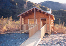
Shoup Bay Marine Park is located 8.5 miles north of Valdez, and is accessible by boat, water taxi out of Valdez, floatplane, or by hiking an 11-mile trail from Valdez. Several cabins are located there. The Shoup Bay State Marine Park cabins are administered by the Alaska Department of Natural Resources (DNR). Be sure to read their Fact Sheet on these cabins.
- McAllister Creek Cabin. 16'X16', sleeps 8, located on the west side of the outer bay, at the outflow of McAllister Creek. CLICK HERE for availability, rates and reservations.
- Kittiwake Cabin. 16'X16', sleeps 8, located along the inner lagoon. Wheelchair accessible. CLICK HERE for availability, rates and reservations.
- Moraine Cabin. 16'X16', sleeps 8, located on the east side of the inner lagoon. CLICK HERE for availability, rates and reservations.
Region 2 Boating Opportunities
Southcentral Alaska offers excellent opportunities for both freshwater and saltwater boaters. The port towns of Cordova, Valdez, Whittier, Seward, Homer, and Kodiak all offer launch facilities, fuel, shore-based lodging, dry boat storage, and permanent or transient berths, fish cleaning stations and many other amenities of interest to power boaters or sailors. All of these locations are within striking distance of outstanding fishing for salmon, halibut, rockfish and ling cod, and all of them provide excellent access to prime public hunting areas.
Region 2 Boat Launch Facilities
Whether you're looking at freshwater or saltwater, you need to know where the launch ramps are. Check out our Region 2 Boat Launches page for locations and instructions.
Saltwater Boating in Region 2
The port towns of Cordova, Valdez, Whittier, Seward, Homer, and Kodiak all offer launch facilities, fuel, shore-based lodging, dry boat storage, and permanent or transient berths, fish cleaning stations and many other amenities of interest to power boaters or sailors. All of these locations are within striking distance of outstanding fishing for salmon, halibut, rockfish and ling cod, and all of them provide excellent access to prime public hunting areas.
Several ports in Region 2 offer permanent and transient slips, boat launch facilities and a host of other amenities of interest to saltwater boaters. In addition, beach-based boat launching is available in the Deep Creek / Ninilchik area. See our Region 2 Boat Launch page for details, schedules and related information.
Anchorage | Cordova | Deep Creek | Homer | Kenai | Kodiak | Seward | Valdez | Whittier
Prince William Sound
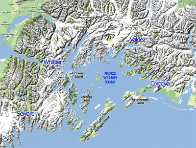 Prince William Sound
The sound is the crown jewel of southcentral Alaska. Home to vast ice fields, deep, glacier-carved fijords, spectacular forested mountains with trails that wind up to beautiful lookouts and an ecosystem that is teeming with fish and wildlife all combine to make Prince William Sound a premier destination for anyone interested in the Alaska outdoors. The Good Friday Earthquake, which took place in March 1964, lifted some areas several feet, and the evidence of this is still visible today. A resulting tsunami inundated much of the town of Valdez; much of the town has been relocated farther inland as a result.
On March 24, 1989, the Exxon Valdez oil tanker ran aground on Bligh Reef, spilling between 260,000 to 750,000 barrels of crude oil, which eventually impacted 1,300 miles of the Sound’s 3,000 miles of coastline.Today there is little visible evidence that the spill ever occurred. Long-term effects are still to be determined. Several tour companies operate day-cruises out of Cordova, Valdez, Whittier and Seward. These harbors are also the origin points for charter fishing operations, and private boaters use these areas to launch out on fishing, hunting, and sightseeing adventures across the Sound.
If you plan to visit Prince William Sound, you would do well to purchase a copy of “The Cruising Guide to Prince William Sound”, by Jim and Nancy Lethcoe. It is an invaluable guide to all the safe anchorages, hazards, weather patterns, hiking trails, and other points of interest for outdoor recreation throughout the Sound.
FAA Web Cams Around Prince William Sound
Cordova | Johnstone Point | Middleton Island | Potato Point | Seward | Valdez | Whittier
Several tour companies operate day-cruises out of Cordova, Valdez, Whittier and Seward. These harbors are also the origin points for charter fishing operations, and private boaters use these areas to launch out on fishing, hunting, and sightseeing adventures across the Sound.
Southcentral Alaska offers the best access of any region in the state for whitewater or flatwater rafters, canoeists, ocean kayakers, powerboaters and sailors. The opportunities are endless, whether you are tied to the road system, or have the ability to fly out to a remote area; it's all there waiting for you.
Kenai Peninsula
The Kenai Peninsula itself offers excellent saltwater opportunities, including sailing, powerboating (by far the most popular) and even sea kayaking. Ocean kayaking is very popular in the Seward area, and also out of Whittier. It is growing in popularity in Kachemak Bay (near Homer), with paddlers crossing the bay on a calm day to visit Halibut Cove, Yukon Island, or the quaint little seaport of Seldovia. Some charterboat operators offer kayak drop-offs and pick-ups by prior arrangements, which give sea kayakers the chance to experience remote areas without having to go to the extra work of paddling all the way. A water taxi service offers day-trippers a departure from Homer to Seldovia, where you can wander the streets, have some lunch or do a little shopping before catching a ride back to Homer and the road system. Although the southern side of the Kenai Peninsula offers rugged, rocky coves and relatively deep water, the north side is a sharp contrast, with shallow, sloping beaches and exposed coastlines for the entire distance. Several locations on the north side of the Kenai Peninsula offer boat launch facilities. There are two ways to launch a boat at the Deep Creek State Recreation Area. You can launch the boat yourself from the beach, but you must have some experience with this before attempting it. Launching must be timed with the tides, with special attention paid to the weather and wind-driven waves. There's a tractor service that can launch your boat off the beach, regardless of the tide. It's expensive, but most boaters believe it's worth it, considering the risk of losing a mired vehicle to a rising tide.
Freshwater Boating in Region 2
Freshwater fishing opportunities abound across Region 2. All five species of Pacific salmon swim it's rivers, and grayling, lake trout, Dolly Varden, Rainbow trout and northern pike can be found in lakes and rivers throughout the area. The road system allows excellent access to many premium fishing areas, and there are also some great fly-out fishing opportunities in Region 2.
Lakes
Region 2 contains many road-accessible and remote lakes. Here are some of the most popular ones; simply click the name to learn more about them.
Kenai Peninsula Lakes
Crescent Lake | Fuller Lakes | Hidden Lake | Kenai Lake | Swanson Lakes | Tustemena Lake
Other Nearby Lakes
Because the border of Regions 2 and 4 adjoin each other just north of Anchorage, it is important to note other waterways that are in the vicinity of Region 2, just to the north of Anchorage.
Big Lake | Finger Lake | Irene Lake | Kepler-Bradley Lakes | Lake Lucille | Long Lake (Willow) | Nancy Lake | Red Shirt Lake | Rolly Lake, North | Rolly Lake, South | Wasilla Lake
Rivers
Region 2 contains several river systems of interest to recreational floaters, including hunters and fishermen. Because this area contains the greatest percentage of the state's road system, it also contains the highest number of road-accessible streams. For floaters who are limited to the road system, this creates an ideal situation where access to some of the state's best rivers are simply a short drive away. On the other side of the coin, ease of access also can mean that these areas are often crowded, particularly on holiday weekends. Floaters looking for an isolated experience can find it in Region 2, but it requires more work than it does in other regions that are mostly or exclusively roadless. Click the river title to read more.
CAUTION: Before embarking on a river trip anywhere in Alaska, do your homework! Double-check your information against details from your air charter, get flow information from the Alaska-Pacific River Forecast Center (APRFC), and other floaters. Check our Boating Forums for discussions with people who have been there. If you are not familiar with the characteristics of Alaska's rivers, read our River Information page for a general orientation, and a list of resources to get you started on the learning process.
Anchor River | Granite Creek | Kasilof River | Kenai River, lower | Kenai River, upper | Moose River | Northern Cook Inlet | Ptarmigan Creek | Quartz Creek | Resurrection Creek | Russian River | Sixmile Creek | Swanson Lake Canoe Trails | Trail River
Region 2 Fishing Opportunities
Fishing throughout this area is excellent for a variety of freshwater and saltwater species. All five species of Pacific salmon are found here, as are halibut, lingcod, rockfish, steelhead, rainbow trout, lake trout, Dolly Varden, grayling, and much more. Because southcentral Alaska offers the best road access in the state, opportunities are excellent for road-based anglers. The Kenai River and the Russian River, arguably two of the best salmon rivers in the entire state, are easily accessed by road, and both offer numerous camping locations and other support amenities for visiting anglers.
Resources
If you plan to fish anywhere on the Kenai Peninsula, you need a copy of Dave Atcheson's "Fishing the Kenai Peninsula" in your rig. If you're new to the area, a copy of The Milepost will help you plan your trip, providing maps and detailed information on the locations of campgrounds, cabins, places to eat, fuel stops and much more. While you're in the bookstore, you might also check out our maps of the Kachemak Bay area, Kenai Lake and Vicinity (includes the upper Kenai River and the Russian River), Kenai River (includes only the middle and lower sections of the river, from Skilak Lake to the mouth), and the Northwestern Kenai Peninsula map, which includes only the areas around Kenai, Soldotna, Sterling, Kasilof, and Nikiski. These are road maps, but they also show campgrounds, fishing areas and available species.
Saltwater Fishing
Fishing opportunities are excellent in the waters of Prince William Sound, offshore from the Kenai Peninsula, and around the Kodiak-Afognak Island archipelago. Common methods for salmon fishing include boat-based trolling and mooching with herring. Shore fishing opportunities are somewhat limited, however shorebound anglers can find great fishing in the Cordova area for silvers, pink salmon, and to a lesser extent, kings. Shotgun Cove in the Whittier area offers great shore-based fishing for silvers. Seward is probably the most popular area for shore fishing for silver salmon, and chums and pinks are also available.
Snagging is legal in these areas, and anglers typically use weighted, sharpened treble hooks for this. Sport fishermen use Vibrax spinners, Pixee spoons, or herring or salmon roe fished under a bobber. Roe is especially effective for silvers. Halibut are occasionally caught off the beaches in the Anchor River, Deep Creek, and Ninilchik areas, as well as the beaches of the Homer Spit. Use herring or octopus on a sliding sinker rig, and longer heavy surf-casting rods to heave your offerings well out past the surf zone for the best results. The water here is relatively shallow; expect depths of less than 25 feet. And, as always, check the fishing regulations for this area to ensure you are legal.
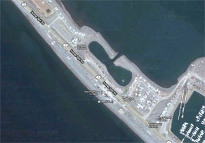 The "Fishing Hole"
The Homer Spit also offers a unique opportunity to catch silvers and king salmon in "The Fishing Hole", an artificial cove built onto the spit a number of years ago. Salmon fry are stocked in this cove, and the adults return to this area to spawn. These fish are caught using roe or troll-sized herring drifted under a float, spoons, spinners, fly tackle and snagging. The Fishing Hole is located on your right as you travel along the Homer Spit, just before you get to the small boat harbor. All of the above-mentioned methods and locations are detailed in Rene Limeres and Gunnar Pedersen's "Alaska Fishing", available in our bookstore. Sea-run Dolly Varden are also available on the Homer spit, and can occasionally be found in the Fishing hole.
Prince William Sound
It is worth noting that Prince William Sound and its connecting bays offer seasonal fishing opportunities for salmon sharks. This is a relatively new and closely-regulated fishery, however for those looking for something truly unique in the way of big-game fishing, several charter outfits offer salmon shark trips. This cousin of the great white shark is an aggressive jumper that takes a variety of large baits. Special rigging is required, and catch-and-release fishing is encouraged. Check out the article by Crackerjack Charter's captain Andy Meziro, "The Shark- Alaska's Toughest Fish" for an exciting read on salmon shark fishing in Alaska.
Check the ADF&G website for details on the following available saltwater species.
Atka Mackerel | Black Cod | Chum Salmon | Cutthroat Trout | Dolly Varden | Halibut | King Salmon | Lingcod | Pink Salmon | Pollock | Red Salmon | Salmon Shark | Silver Salmon | Steelhead | Yelloweye Rockfish
Shrimping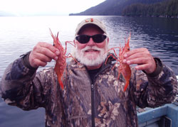
Prince William Sound contains a healthy population of spot shrimp, with both a commercial and a sport fishery targeting this species. The meat is sweeter than most shrimp, and they are highly prized on the dinner table. Shrimping is done with pots which are baited and dropped into waters in excess of 300' deep, and left to "soak" for several hours. This pot fishing technique is considered the most environmentally friendly method of shrimping, with virtually no seafloor damage and almost no bycatch of other species. Recreational shrimpers typically go out for a weekend, and may drop six or eight pots in an area, then go fishing for a while and pull their pots at the end of the weekend. Mark the buoys on your pots with your name and address, ensure they have plenty of line on them to accommodate the rising tide and currents, and take a GPS reading on their location. The amount of line you need greatly depends on the water depth; plan on twice as much line as the anticipated depth. Because of the great depths involved, most shrimpers use a "pot puller"; a hydraulic winch mounted to the boat, to pull the pots up from the seafloor. Keep track of your pots! If you didn't put enough line out, the rising tide or changing currents can lift your pots and cause them to drift off into deeper water. Fishermen can be cited for unrecovered pots that are left out after the season closes. Pot theft remains a problem in accessible areas of the Sound, so check your pots more often, or position them where you can easily spot other boats in the vicinity. Visit our Saltwater Fishing Forum for more information on shrimping locations, how-tos and other details that will make your efforts more productive.
Check the ADF&G website for information on the following shellfish found in Prince William Sound.
Coonstripe Shrimp | Northern Shrimp | Sidestriped Shrimp | Spot Shrimp | Golden King Crab | Red King Crab | Tanner Crab
Clamming
Many places in Region 2 offer clamming opportunities. Some of the best road-accessible areas include the beaches near Ninilchik, Anchor River, Clam Gulch and Deep Creek. All of these areas offer opportunities to camp, and some have portable restroom facilities. If you have a 4WD vehicle, you can drive onto the beach areas, but you must use extreme caution to avoid soft sand spots, and mud extrusions that sometimes squeeze up through the sand. These look like rocks from a distance, giving the impression of stable driving, but the opposite is true. Drive there, and risk burying your rig. Most people park on the hard-packed sand just below the high water mark, and ensure that they are out of there before the tide rises. These are popular clamming areas where you can essentially follow the crowd to the best areas.
Check out our writeup: Razor Clamming Alaska's Cook Inlet by Mari Reeves
Remote, boat-accessible clamming opportunities exist across Kachemak Bay. Check out Halibut Cove, Sadie Cove, Jackalof Bay and others listed below.
CAUTION: Paralytic Shellfish Poisoning (PSP) has caused several deaths in Alaska. The Alaska Department of Fish & Game regularly tests and certifies certain beaches as PSP-free. Limit your clamming to these beaches to avoid the risk of PSP. The ONLY certified beaches in the state of Alaska are all in the Lower Cook Inlet / Kachemak Bay area, as follows: Polly Creek, Crescent River, Chugachik Island, Halibut Cove, Sadie Cove, Tutka Bay, Jackalof Bay and Kasitsna Bay (McDonald Spit).
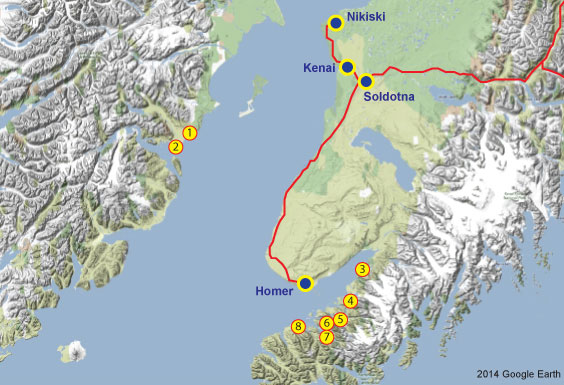
Certified PSP-Free Beaches in Alaska
- Polly Creek: Requires fly-out from Anchorage, Kenai / Soldotna or Homer.
- Crescent River: Requires fly-out from Anchorage, Kenai / Soldotna or Homer.
- Chugachik Island: Requires fly-out from Homer or 16.5 mile boat run northwest of Homer boat harbor.
- Halibut Cove: Requires fly-out from Homer or 8.4 mile boat run west of Homer boat harbor.
- Sadie Cove: Requires 14-mile boat run southeast from Homer boat harbor. Clamming is at the head of the bay.
- Tutka Bay: Requires a 17.6-mile boat run southeast from Homer boat harbor. Clamming is at the head of the bay.
- Jackalof Bay: Requires a 13.6-mile run southeast from the Homer boat harbor. Clamming is at the head of the bay.
- Kasitsna Bay (McDonald Spit): Requires an 11.7-mile boat run south from Homer boat harbor. The most direct route is along the north side of Yukon Island, however in rougher weather a more sheltered route is to cut across Kachemak Bay and duck in behind Yukon Island via Eldred Passage to McDonald Spit. Clamming is in the flats between the spit and the mainland.
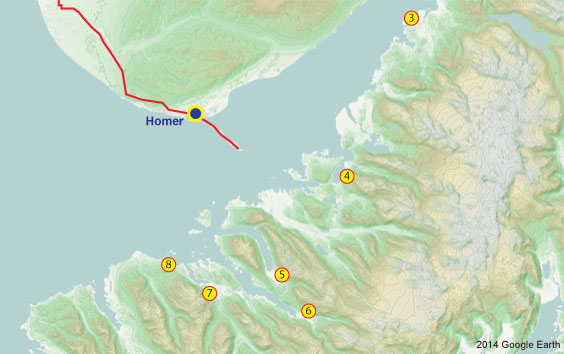
The above map shows the details of the locations of PSP-free beaches in Kachemak Bay. Note that in most cases the ideal clamming locations are at the head of the bays, where mud flats are exposed at low tide.
Species
Check out these species pages for the types of fish you may encounter on the Kenai Peninsula:
King Salmon | Pink Salmon | Red Salmon | Silver Salmon | Chum Salmon | Halibut | Hooligan | Lingcod | Pacific Cod | Rockfish | Salmon Shark | Grayling | Lake Trout | Pike | Rainbow Trout | Dolly Varden
Regional Details
For details on specific fishing areas in Region 2, including amenities and equipment / service providers in these locations, please visit our pages on the following areas:
Anchorage | Cordova | Homer | Kenai / Soldotna | Kodiak | Northern Cook Inlet | Prince William Sound | Seward | Valdez | Whittier
Resources
If you plan to fish anywhere on the Kenai Peninsula, you need a copy of Dave Atcheson's "Fishing the Kenai Peninsula" in your rig. If you're new to the area, a copy of The Milepost will help you plan your trip, providing maps and detailed information on the locations of campgrounds, cabins, places to eat, fuel stops and much more. While you're in the bookstore, you might also check out our maps of Kachemak Bay State Park, Kenai River (includes only the middle and lower sections of the river, from Skilak Lake to the mouth), and the Northwestern Kenai Peninsula map, which includes only the areas around Kenai, Soldotna, Sterling, Kasilof, and Nikiski. These are road maps, but they also show campgrounds, fishing areas and available species. Finally, check out Scott Haugen's excellent book, "Bank Fishing for Steelhead and Salmon" for excellent tips that will work on the Kenai River, Deep Creek and other places on the Kenai Peninsula.
Region 2 Hunting Opportunities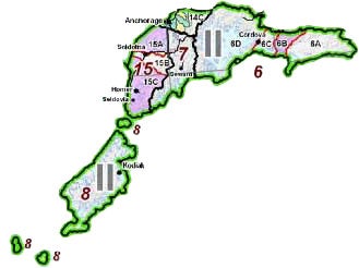
The state of Alaska is divided into 26 Game Management Units (GMU), some of which are divided further into sub-units. Each of these units or sub-units may contain different species, different seasons, and different legal requirements for hunting. GMUs are aggregated into regional groupings, and each of these regions operate under the oversight of a team of ADFG employees, including area biologists who are responsible for game management in their assigned portions of the region. There are five regions in the state of Alaska. Outdoors Directory uses these regions to divide the state into smaller pieces, for the sake of organization. When you plan your Alaska hunt, you need to know both the GMU in which you will be hunting, and the region. In this way you can ensure you are following the correct regulations for the area, and you know which regional biologist to contact for details about that area.
Region 2 contains GMUs 6, 7, 8, 14(C) and 15, and covers 25,645 square miles (an area slightly larger than the state of West Virginia). The ADF&G Region 2 office is located in Anchorage.
Check out our page on Hunting Southcentral Alaska for more specifics.
Anchorage and Kenai Peninsula
Because Region 2 contains an extensive road system, it has a correspondingly higher amount of recreational activity. Hunters should expect to see other hunters, hikers, campers and other recreational users. Be sensitive to others around you. Though the road system offers access to many areas, it does not necessarily follow that all the trails off the road system are crowded with hunters. There are many pockets of huntable terrain that offer excellent opportunities for a variety of game. You must do your homework, including some pre-season scouting in new areas. And learn to be crafty! If someone sees you pulling out of a dirt road with a 60" moose rack in the back of your pickup, they are going to remember that spot and you may have company next time. The honey holes near the road system are some of the best-kept secrets in Alaska.
Region 2 offers a number of fly-out hunts, or boat-based hunts. The Cordova area has some excellent moose opportunities, however a boat is almost a requirement to get to the better areas. Unit 14C offers some of the best Dall sheep hunting in the state, but it is done by drawing, so get your name in on time and make your air charter arrangements as soon as you know you have a tag. The Kenai Peninsula was legendary for its moose population around the turn of the century, however the habitat has mostly recovered from the old burns that were there years ago and the habitat has gotten less favorable for moose. Even so, the Tustemena Lake area (draw hunt) is known to produce some large bulls, and other areas on the Kenai are good for moose hunting. The Kenai Peninsula also offers good hunting for goat, Dall sheep, brown / grizzly bear and even caribou. As is true anywhere else in Alaska, good research will help you choose a productive location.
Other Hunting Areas in Region 2
Click the links below for specific information on areas to hunt in Region 2.
Species Information
Want to learn more about the critters that inhabit southcentral Alaska? Visit our species pages, where you'll find detailed instructions on the biology, distribution and how to hunt the big-game species that inhabit this area. Here are direct links to our pages on the species found in this region:
Bison | Black Bear | Brown Bear | Caribou | Dall Sheep | Elk | Goat | Moose | Sitka black-tailed deer | Wolf
ADF&G Region 2 Information
ADF&G Management and Harvest Reports, a vital hunt-planning tool, can be found AT THIS LINK. Reports are listed in sequential order by species. For detailed research into population trends, review several reports. For more recent data contact the area biologist. The Region 2 biologists are located in Anchorage. The phone number there is 1 (907) 267-2257.


