Region 3 East: Eastern Arctic, Eastern Interior
The dividing line between Region 3 (east) and the western portion of Region 3 is the Dalton Highway (the "Haul Road") from Prudhoe Bay south to Fairbanks, and south along the George Parks Highway. This area includes the bulk of the Alaska oil pipeline, including the oilfields at Prudhoe Bay.

Region 3 (east) includes the eastern end of the Brooks Range, stretching to the Canadian border area, along with a significant portion of the Interior. It contains the beginning of Alaska's portion of the Yukon River, the longest river in the state. Much of the land in this area is covered in open tundra, but vast portions are carpeted by black spruce forests instead. Some salmon fishing can be had in this area, however most of the region is far from the ocean, so it does not see the larger runs found in other regions. Fishing for grayling and northern pike is excellent, and there are numerous opportunities for rainbow trout, lake trout, and char. Big game species commonly encountered here include Dall sheep, moose, caribou, black bear and brown / grizzly bear.
The Road System
The road system in Region 3 provides good coverage to most of the area, and links all the principal towns throughout. The State of Alaska does a pretty good job of maintaining our paved roads, however some roads located in outlying areas may not receive as much attention. A common problem is "frost heaves"; cracks across the roadway that are caused by the expansion and contraction of the roadbed as it freezes and thaws. In some cases the asphalt can crack all the way across the road bed, leaving bumps and dips in the road that can cause problems for drivers traveling at higher speeds.
 The Alaska Milepost details everything you need to know about driving the remote highways in Alaska, including camping areas, pullouts, fuel stops, and lots of good tips on avoiding trouble. The Milepost is a must-have for any extended road trips you take in Alaska, as it contains many tips on what you need to bring with you, and what you need to know simply to survive on Alaska's highways, where the nearest help may be hundreds of miles away. Pick up your copy HERE.
George Parks Highway
Known locally as the Parks Highway, this is the main artery between Anchorage and Fairbanks. It runs north from Anchorage, through the towns of Wasilla, Willow, Cantwell, Nenana and eventually Fairbanks. Drivers should be alert for moose crossing the highway just about anywhere, but particularly in the area between Wasilla and Willow. Also be aware that the long stretch between Cantwell and Nenana is not always as well-maintained as sections closer to Anchorage or Fairbanks, and drivers may encounter occasional frost heaves.
Elliot Highway
Continuing north of Fairbanks, you can travel the paved Elliot Highway 80 miles to Livengood, then take the Dalton Highway, a gravel and dirt road that parallels the Alaska Pipeline for the entire 360 miles to Prudhoe Bay, on the shores of the Arctic Ocean.
Dalton Highway (the Haul Road)
When traveling the Dalton, be aware that it is primarily a truck route for big rigs that supply the Prudhoe Bay oilfield operation. Keep out of their way; the road has numerous single-lane bridges and you must yield to truck traffic. Because the road is very long with few services along the way, you must be self-contained. Keep your gas tank full! As an added precaution consider bringing along a CB radio, tuned to Channel 19. This is the frequency most commonly used by truckers in the area. If you have an emergency, you may be able to get a message out to a passing trucker.
 The Bureau of Land Management produces a very informative guide to the Haul Road, which includes maps and detailed instructions. There are several ways to obtain this free booklet:
- CLICK HERE to read the guidebook online, save it to your desktop (and take it with you on your mobile device).
- This email address is being protected from spambots. You need JavaScript enabled to view it. for a free hard copy.
- Call the Fairbanks BLM office at 1 (800) 437-7021 or 1 (907) 474-2200
- Write to the BLM to request a free hard copy at the following address:
Central Yukon Field Office
1150 University Avenue
Fairbanks, AK 99709-3844
The Steese Highway links Fairbanks and Circle, on the banks of the Yukon River to the north. Begin at Fairbanks and travel north to Fox. Take the right-hand fork out of Fox and you are on the Steese Highway. From there you can travel north to Central, where you may opt to take the side road to the east, which puts you at Circle Hot Springs. If you go straight north from Central, you end up in Circle, where the road ends.
Richardson Highway
The Richardson Highway links Fairbanks to Delta Junction, Paxson, Gakona, Glenallen and Valdez. It runs through the heart of the Interior and provides access to some of the region's best road-accessible fishing and hunting.
Alaska Highway
Built in 1942 in response to potential threats to the United States during WWII, the Alaska-Canada Highway (the Alcan) begins in Dawson Creek, British Columbia and officially terminates 1,422 miles to the north in Delta Junction, Alaska. Originally constructed as a gravel road, the Alaska portion of the highway was paved in the 1960's and many sections have been straightened over the years, making the journey faster and safer.
Taylor Highway
The Taylor Highway begins at Tetlin Junction on the Alaska Highway (11 miles south of Tok), and continues north 160 miles, passing through Chicken and ending at Eagle, on the banks of the Yukon River. At Jack Wade Junction (mile 96), you can turn off onto the Top of the World Highway (State Highway 9), which continues eastward 79 miles to Dawson City, in the Yukon. The Top of the World Highway offers some access to parts of the Fortymile River. The first 60 miles out of Tetlin Junction are paved, and the rest is gravel. The road is closed to automobile traffic from October through April, but it sees some snowmobile traffic in the winter. The Taylor Highway is the primary road access for hunters in pursuit of caribou from the Fortymile Herd. It crosses several forks and tributaries of the Fortymile River, offering road access for float trips.
Public-Use Cabins
Region 3 (east) contains many cabins that are available for use by the general public. Most require advance reservations and user fees are usually charged by the night. Amenities are spartan; expect to find an outhouse, bunks with no bedding or mattresses, no food, no dishes or cookstove, and no power or running water. Most have wood-fired or oil-fired stoves for heat. See our Public-Use Cabins page for locations, recommended gear, reservation and contact information.
Flying Out in Region 3
A number of towns in Region 3 (east) offer opportunities to hire an air charter / air taxi service to drop you off for remote hunting, fishing or other recreational opportunies.
Coldfoot
Located on the Dalton Highway north of Fairbanks, Coldfoot is the last gas stop before you reach Prudhoe Bay, 250 miles to the north. This is also the last place you can charter a Bush flight until you reach Happy Valley. Coldfoot offers wheel plane access to remote locations in the central and eastern Brooks Range. Most folks utilizing these services park their vehicle at the air service, where it is secure until the return.
Delta Junction
Delta, located in the heartland of the Interior, is accessed primarily off the road system. They do, however, offer limited air charter services that can get you in to remote locations in GMUs 13 and 20. Delta Junction truly has the "small town" atmosphere, and it has become a regional hub for outdoor activity. Check out the Delta News Web for up-to-the-minute details on what's going on around town, including local fishing and hunting reports and info.
Fairbanks
Fairbanks, the largest town in Region 3, offers both float and wheel plane charters to get you into remote locations in the Brooks Range and throughout the central part of the region. Fairbanks also offers regularly scheduled jet service from Anchorage and even direct flights to and from Seattle. Additionally, flights are available from Fairbanks to Bettles, Galena, and other remote towns off the road system. Finally, Fairbanks offers daily air cargo service through a variety of carriers.
Fort Yukon
Fort Yukon is frequently used as a staging / refueling stop by air charter services out of Fairbanks, however there are no regularly-scheduled air charter services based there.
Happy Valley
Happy Valley Camp, located on the Alaska Oil Pipeline, is an oilfield service camp just south of Prudhoe Bay. Charter wheel-plane services are available there for flights into the north-central Brooks range, however the early arrival of winter in this area makes scheduling remote drop-offs and pick-ups in this area an iffy proposition after the middle of September. Drive there from Fairbanks or Prudhoe Bay.
Tok
Tok is located at the intersection of the Glenn and Alaska Highways. It's a small community with limited opportunities to charter air services into GMUs 13 and 20. Tok does, however, provide a much-needed fuel stop for travelers coming over from Anchorage on the Glenn Highway or folks coming in from Canada on the Alaska Highway.
Region 3 Boating Opportunities
The interior contains several large river systems that can be accessed from Alaska's road system. These access points provide launch opportunities for jet boats and air boats, which are often used to access prime fishing and hunting areas.
Rivers
A number of rivers flow north or south out of the Brooks Range, and these rivers offer excellent floating for fly-out rafters, canoeists, and kayakers interested in multi-day expedition river trips. Additionally there are other rivers both on and off the road system that offer excellent opportunities for recreational boating and related experiences such as float fishing and float hunting.
Beaver Creek | Black River | Chatanika River | Copper River | Delta River | Fortymile River | Gulkana River
Lakes
Region 3 contains many road-accessible and remote lakes. Here are some of the most popular ones; simply click the name to learn more about them.
Arizona Lake | Bearcub Lake | Buffalo Lake | Connor Lake | Crosswind Lake | Crater Lake | Dick Lake | DJ Lake | Forgotten Lake | Gergie Lake | Junction Lake | Lake Louise | Little Crater Lake | Little Junction Lake | Moose Lake | North Jans Lake | Old Road Lake | Paxson Lake | Peanut Lake | Pippin Lake | Round Lake | Ryan Lake | Sculpin Lake | Silver Lake | South Jans Lake | Squirrel Creek Pit Lake | Strelna Lake | Susitna Lake| Tex Smith Lake | Three Mile Lake | Tiny Lake | Tolsona Mountain Lake | Town Lake | Van Lake
Region 3 Fishing Opportunities
This area offers some of the best northern pike fishing in the state, together with top action on grayling, lake trout, char and some rainbow trout opportunities.
Region 3 Hunting Opportunities
Alaska Hunting Regulations | Alaska Hunt Planning Resources | Alaska Hunt Consultation Service
The state of Alaska is divided into 26 Game Management Units (GMU), some of which are divided further into sub-units. Each of these units or sub-units may contain different species, different seasons, and different legal requirements for hunting. GMUs are aggregated into regional groupings, and each of these regions operate under the oversight of a team of ADFG employees, including area biologists who are responsible for game management in their assigned portions of the region. There are five regions in the state of Alaska. Outdoors Directory uses these regions to divide the state into smaller pieces, for the sake of organization. When you plan your Alaska hunt, you need to know both the GMU in which you will be hunting, and the region. In this way you can ensure you are following the correct regulations for the area, and you know which regional biologist to contact for details about that area.
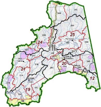 Region 3 (east) contains GMUs 12, 20(A), 20(B), 20(D), 20(E), 24(A), 25, 26(B) & 26(C), and is administered out of the Fairbanks office of the Alaska Department of Fish and Game.
The area offers opportunities for moose, caribou, brown/grizzly bear, black bear, Dall sheep and wolf. There are ample waterfowl opportunities as well as upland bird hunting for grouse and ptarmigan. As is true in most of Alaska, small game hunting includes showshoe hare, with populations that fluctuate from year to year.
Species Information
Want to learn more about the critters that inhabit the eastern Arctic and Interior Alaska? You'll find detailed information on the area's big-game species found in this area in our Species Pages.
Bison | Black Bear | Brown Bear | Caribou | Dall Sheep | Moose | Muskoxen | Wolf
ADF&G Region 3 Information
ADF&G Management and Harvest Reports, a vital hunt-planning tool, can be found AT THIS LINK. Reports are listed in sequential order by species. For detailed research into population trends, review several reports. For more recent data contact the area biologist.
The ADF&G biologists for Region 3 are located in Fairbanks. The phone number there is 1 (907) 459-7206.
Other Activities in Region 3
There are many more outdoor recreational opportunities in Region 3; click the title above for some ideas.