Alaska's Rivers
Alaska is over twice the size of Texas, but our road system seems about the size of Hawaii. To the casual observer it appears that the vast majority of the state is inaccessible. And that would be true if it were not for our rivers. We have over 365,000 miles of rivers interlaced all across the state, and in many ways, these rivers are our roads. Larger rivers such as the mighty Yukon or the Kuskokwim, are the equivalent of superhighways, providing access for barges filled with needed supplies destined for villages along the banks. Other rivers, such as the Susitna, the Tanana and the Porcupine serve as liquid (or frozen) highways used to visit friends and family, or for recreational purposes. Smaller rivers and streams are frequently used for subsistence activity, recreational hunting and fishing, or for access to hiking areas.

About Alaska's Rivers
Alaska has over 365,000 miles of rivers within its borders. The character of our rivers is widely varied; some are little more than meandering streams, while others are wide, mighty flows used for commercial freight traffic to villages along their banks. Recreational floaters must carefully research the character of the river they intend to float, or risk serious danger. Here is a general introduction to the characteristics of rivers found in Alaska.
How Many Rivers in Alaska? The actual number of rivers in Alaska is not easy to calculate. According to one source, the state has over 12,000 rivers, however not all these rivers are named. And there is the question of what exactly constitutes a river, anyway? Criteria can be established based on length, navability or volume (which is usually seasonally variable) or any of several other factors. Regardless of the metric used, Alaska has thousands of rivers available for recreational users. Hundreds of those rivers are listed here on this site.
Private Property
Private property in Alaska is not usually fenced or posted, yet it is the user's responsibility to avoid trespassing on private lands. Some lands are owned by the state or federal government, and not all these lands allow aircraft access. In some areas hunting is restricted or prohibited. Other lands may be owned by individuals or native corporations or reservations. In many cases private land owners charge a user fee and others access is forbidden at any price. Check with the Bureau of Land Management's Public Lands Information Office for a list of land owners and contacts before heading afield.
Glacial Rivers
A significant portion of Alaska's fresh water is locked in glacial ice. Glaciers are made of densely-compacted ice that is often thousands of feet thick. Because glaciers lie in sloped valleys, the sheer weight of the ice causes it to slowly flow downhill. As the ice moves, it scours the substrate beneath it, eventually down to bedrock. Glaciers scour the rock into fine powder, known as glacial silt or glacial flour. As the glacier
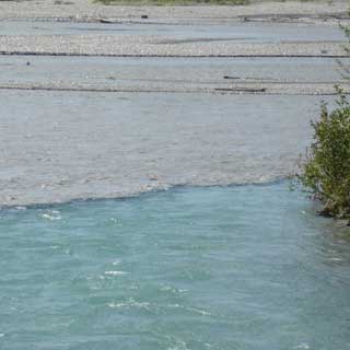 starts to melt during the spring and summer months, this silt is mixed into the melt water. Glacial silt is fine and usually remains in suspension in the water for the entire length of the river. What this means to boaters is that the water will be opaque, ranging in color from the greenish-blue of the Kenai, to the concrete color of the Susitna, Klutina, and many others. This limits boaters to reading the water by surface indicators alone. Rocks that are just below the surface are invisible, except for the bulge they make in the surface.
Use extreme caution on glacial rivers, to avoid grounding out on submerged rocks that cannot be seen from the surface.
Another hazard presented by glacial rivers is the silt itself. A boater who falls overboard finds their clothing quickly penetrated by silt, which weighs them down and makes it hard to swim. This, added to the very low temperatures of glacial rivers, means that a boater taking an unexpected swim may sink like a stone unless they are wearing a life jacket and can be fished out of the river right away. Never float a glacial river without wearing a life preserver and having a rescue throw bag in reach on the boat. Brief all passengers on the proper use of the rescue line, should someone fall overboard.
WARNING: Water in remote areas of Alaska may be contaminated with giardia or cryptosporidium, and should be treated before you drink it.
Most floaters filter their water, but on glacial rivers the silt can quickly clog your filter. Because the silt in glacial water is so fine, it remains in suspension for hours or even days. A great way to treat it is through boiling. The molecules expand during the boiling process, allowing the silt to settle to the bottom. Pour off the top of the container and your water will be silt-free. For more info on giardia and water treatment options, read our magazine article "Don't Drink the Water" by Michael Strahan.
Timbered Rivers
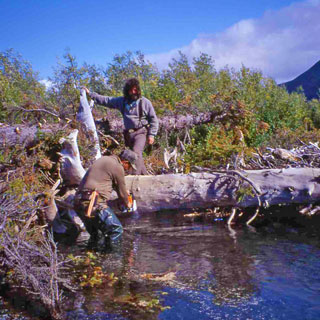
Rivers flowing through timbered country (pretty much most areas south of the Arctic Circle have this potential), may find themselves dealing with downed timber in the river. As the spring floods come through, they may scour the outside bank of the river, eroding soil and undermining trees and brush along the banks. The trees fall into the river and are pushed downstream where they collect along the outside of bends, in shallow water, or in back-eddy areas. On narrow rivers, logs can completely block the channel, and as other trees are washed down, logjams form. In some cases these jams may form on the downstream end of a blind curve. Careless boaters find themselves trapped in a logjam, where the risk of great bodily harm or death is very high.
If you're floating a remote river requiring aircraft access, fly your route to scout for hazards. Mark these areas on your maps and keep an eye out for them as you float through. Digital photographs taken from the air during your flyover can be a huge help in identifying these places as you approach them.
If you are not positive that the area you are floating into is hazard-free, pull the boat over, tie it off and scout the area on foot.
Ice / Aufeis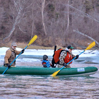
Besides glaciers (discussed above), boaters must also contend with ice on some rivers. The amount of ice involved depends on the latitude of the river, the time of year, and climate conditions. During the winter months most rivers freeze over, and with the accumulation of snow on top of the ice, it isn't too long before the ice is many feet thick. During spring this ice begins to melt, and breaks up, flowing downstream until it melts, drifts out into the ocean, or grounds out on a shallow gravel bar. This remaining ice is known as aufeis (pronounced "off-ice"), and in some cases it may remain until the next winter. In most cases it is gone by July. Boaters should fly the river carefully if aufeis is a possibility. Failure to do this could result in tragedy. If you encounter aufeis in the river and cannot maneuver out of the way in time, your boat may become trapped under the ice and the occupants of the boat may drown.
River Terminology
Many specialized terms are used to describe river features, hazards, maneuvers, etc. Here is a basic list; other terms can be found in any of several river books available in our store.
Highside: A boating maneuver used when a boat is pinned against an obstacle in moving water. Boaters clamber up onto the "high side" of the boat (usually the downstream side), to force the other side up out of the water to prevent capsizing or swamping.
River Right / River Left: Refers to the right or left side of the river while facing downstream. This term is often used to direct passengers to a point of interest, or a hazard as it is approached while floating.
Strainer: Refers to an obstacle in the river that allows water to pass through, but which traps boats, gear or passengers. Logjams are one type of strainer, as are fallen trees with limbs embedded in the river bottom, and boulder fields with limited flow between them.
Sweeper: Refers to trees that are leaning over the river low enough for the branches or trunk to "sweep" items or passengers off the boat as the boat floats under the obstacle.
Whitewater Scale")
The International Scale of River Difficulty is the accepted standard of measuring the difficulty of a given stretch of river. In applying this scale to Alaska rivers, there are a few things to keep in mind. First, many of Alaska's rivers are not "formally" classified, but their respective ratings, derived from among the boating community, appear in various books and DVDs. The ratings are therefore somewhat arbitrary. Second, some authors give Alaska rivers one more degree of difficulty because of water temperature and the remoteness / difficulty of rescue dynamic involved. The main thing to remember is that many rivers in Alaska are dangerous, and the chances of rescue are influenced by difficulty of aircraft or helicopter access, weather, and other factors. These issues should be foremost in the minds of floaters.
Class I: Fast moving water with riffles and small waves. Few obstructions, all obvious and easily missed with little training. Risk to swimmers is slight; self-rescue is easy.
Class II: Novice. Straightforward rapids with wide, clear channels which are evident without scouting. Occasional maneuvering may be required, but rocks and medium-sized waves are easily missed by trained paddlers. Swimmers are seldom injured and group assistance, while helpful, is seldom needed. Rapids that are at the upper end of this difficulty range are designated as "Class II+".
Class III: Intermediate. Rapids with moderate, irregular waves which may be difficult to avoid and which can swamp an open canoe. Complex maneuvers in fast current and good boat control in tight passages or around ledges are often required; large waves or strainers may be present but are easily avoided. Strong eddies and powerful current effects can be found, particularly on large-volume rivers. Scouting is advisable for inexperienced parties. Injuries while swimming are rare; self-rescue is usually easy but group assistance may be required to avoid long swims. Rapids that are at the lower or upper end of this difficulty range are designated "Class III-" or "Class III+" respectively.
Class IV: Advanced. Intense, powerful but predictable rapids requiring precise boat handling in turbulent water. Depending on the character of the river, it may feature large, unavoidable waves and holes or constricted passages demanding fast maneuvers under pressure. A fast, reliable eddy turn may be needed to initiate maneuvers, scout rapids, or rest. Rapids may require "must" moves above dangerous hazards. Scouting may be necessary the first time down. Risk of injury to swimmers is moderate to high, and water conditions may make self-rescue difficult. Group assistance for rescue is often essential but requires practiced skills. A strong eskimo roll is highly recommended. Rapids that are at the lower or upper end of this difficulty range are designated "Class IV-" or "Class IV+" respectively.
Class V: Expert. Extremely long, obstructed, or very violent rapids which expose a paddler to added risk. Drops may contain large, unavoidable waves and holes or steep, congested chutes with complex, demanding routes. Rapids may continue for long distances between pools, demanding a high level of fitness. What eddies exist may be small, turbulent or difficult to reach. At the high end of the scale, several of these factors may be combined. Scouting is recommended but may be difficult. Swims are dangerous, and rescue is often difficult even for experts. A very reliable eskimo roll, proper equipment, extensive experience, and practiced rescue skills are essential. Because of the large range of difficulty that exists beyond Class IV, Class V is an open-ended, multiple-level scale designated by Class 5.0, 5.1, 5.2, etc... each of these levels is an order of magnitude more difficult than the last. Example: increasing difficulty from Class 5.0 to Class 5.1 is a similar order of magnitude as increasing from Class IV to Class 5.0.
These runs have almost never been attempted and often exemplify the extremes of difficulty, unpredictability and danger. The consequences of errors are very severe and rescue may be impossible. For teams of experts only, at favorable water levels, after close personal inspection and taking all precautions. After a Class VI rapids has been run many times, its rating may be changed to an appropriate Class 5.x rating.
(source: American Whitewater Affiliation Safety Code)
Boating Terminology
C-1: Refers to a single-place canoe or canoeist. C-1 canoeists typically kneel in the center of the boat, using a single-blade paddle.
C-2: Refers to tandem canoes or tandem canoeists.
K1: Refers to single-place kayak or kayaker. K-1 kayakers typically use a double-bladed paddle.
River Gear
Because each river trip is different, it's important to work off of a checklist when you prepare for your trip. At a minimum, each passenger should have the following items:
-
Type III-IV Coast-Guard approved life jacket. A lighter jacket may not provide the buoyancy needed to overcome the weight of heavy clothing, glacial silt, etc.
- Rain Gear or Dry Suit. Very handy to have close at hand in whitewater situations.
- Rubber Boots or river sandals if the weather is warm. Several styles are available. Choose boots that you can kick off of your feet if necessary to swim.
- Dry change of clothes. Put your extra clothing in a small rafting dry bag.
- Polarized sunglasses. They penetrate the sun's glare and allow you to see obstacles submerged just under the surface.
Are Your Sunglasses Polarized? Put the lenses of two glasses together and turn one lens 90 degrees to the other. If both lenses grow dark, the glasses are polarized. If the lenses do not grow darker, they are not polarized.
Our Articles on Alaska's Rivers
Check out the following articles from our archives:
- A Float Hunter's Window by Larry Bartlett
- Alaska Roadside Family Rafting Opportunities by Jeff Varvil
- Don't Drink the Water by Michael Strahan
- Float Hunting Alaska by Jeff Varvil
- Flowing Towards Heaven: Kings and Calm on the Aniak by Jeff Varvil
- Hypothermia, Rhabdomyolysis and Near Death on Beaver Creek by Lee Phillips
- Salmon Fishing the Tsiu River by Jeff Varvil
- Steelhead Fishing Kodiak's Karluk River by Steve Andresen
- Survival in Alaska Whitewater by Jeff Varvil
- The Aniak Float Fishing Trip from Hell; I Never Saw it Coming by Jeff Varvil
- World Class Fishing: The Kenai River by Jim Durkin
Books & Print Resources
A number of commercially-available resources contain vital details on river systems in Alaska. Here is a list of books and DVDs that include river information, along with which rivers are discussed. Keep in mind that some of these rivers are contained within national parks, where hunting is prohibited, while others are steep whitewater creeks that are impractical for float hunting purposes. Do proper research before committing to an expedition river trip!
Several titles in our store are of interest to river folk; visit our special section featuring over 40 titles containing specific Alaska river information, kayaking, rafting and canoeing information and special interest topics such as float hunting and float fishing trips. Specific titles of interest include the following:
More Alaska River Information
Forums
Our Forums are filled with folks interested in Alaska's rivers, and a great place to learn about the details involved in choosing appropriate boats for specific river systems, figuring out how to get there, available activities and trip timing. The following forums would be worth a look:
Alaska Freshwater Kayaking Forum
Alaska Freshwater Fishing Forum
There is no charge for viewing our forums, however registration is required in order to participate in the conversation. All you have to do is call or email our office. We will open the gate for you! Our contact information is at the bottom of every page on our site. We welcome your participation in our forum community!