Region 2 East: North Gulf Coast, Prince William Sound
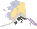
Region 2 East includes the coastal waters associated with Prince William Sound from the Cordova area north and west, extending west to include the entire Kenai Peninsula. This page is focused on the North Gulf Coast and the waters of Prince William Sound.
Alaska Fishing: Prince William Sound, Kenai Peninsula
The portion of Region 2 covered on this page is bordered on the north by the Turnagain Arm of Cook Inlet and includes the coastal waters associated with Prince William Sound and the entire Kenai Peninsula. This area hosts some of the best road-accessible fishing in the state, along with perhaps the two most popular salmon rivers in the entire state, the Kenai and the Russian River. This is also a popular jump-off point for saltwater halibut, lingcod, rockfish and salmon fishing out of Valdez, Whittier, Seward, the Deep Creek / Ninilchik area and Homer.
Places
No matter what you love about Alaska; no matter what you do, how you do it or who you are with, it's ultimately tied with where you are. It's all about Place.

The Alaska outdoors: What is Alaska like?
Alaska is a vast land with diverse ecosystems, boundless expanses of forest, high arctic plains, thousands of miles of rivers, and entire mountain ranges within its borders. It is possible to spend a lifetime exploring the state and never see the same place twice. As you plan your Alaska outdoors trip, you need to know what to expect in the region you are visiting. What is the weather like? What are the terrain & vegetation like? What rivers flow through the area? What facilities are available? Can the area be accessed by road, or is flying necessary? Here you will find details on these, and more. We constantly update these pages, so if you don't find what you need, bookmark the page and check back.
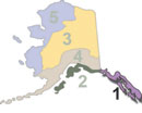
Region 1 South: Southeast Alaska Panhandle
Southeast Alaska, commonly referred to as "The Panhandle", comprises a number of large islands and a strip of coastline that borders British Columbia to the east. The area is roughly 480 miles long and 100 miles wide, depending on where the measurement is taken. This region is the timber capitol of the state, and receives the highest annual rainfall in the entire state. Ketchikan is typical of the area, receiving an average of over thirteen feet of rain per year.
More Articles ...
Subcategories
Panhandle-Northern
This is the category where all activities pages for the northern Alaska panhandle go.
Panhandle-Southern
This is the category where all the activity pages for the Alaska southern panhandle go.
Rivers
Pages focusing on river systems in Alaska, including recreational opportunities on specific rivers, resources for more information on these rivers, and a master river list.
